Tornadoes and Damaging Winds Likely as Big Severe Storm Line Targets Florida Panhandle and North Florida Saturday May 2 With Classic Jet Stream and Humid Air Setup Accelerating Timing to Midday
FLORIDA PANHANDLE, FL — A significant timing change in the cold front forecast elevated the Saturday, May 2, 2026 severe weather threat for Florida, as what once appeared to be a Sunday arrival accelerated to a Saturday midday into afternoon timeline, bringing a large line of severe storms across the Florida Panhandle and north Florida with tornadoes and damaging winds considered likely threats across the highest risk zone.
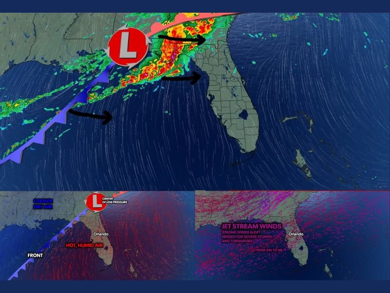
Forecast imagery valid at 8:00 AM Saturday, May 2 showed an active and intense storm line pushing into the Florida Panhandle from the northwest, driven by a well-defined low pressure center positioned over the Gulf region and supported by strong jet stream winds aloft tracking from southwest to northeast across the state.
Classic Florida Severe Weather Setup Takes Shape
The atmospheric ingredients in place for the Saturday severe weather event represented a textbook setup for significant tornado and damaging wind development across Florida. Strong low pressure aloft combined with fast jet stream winds, hot and humid surface air pushing northward across the state, and cooler dry air advancing behind the front from the northwest created the classic convergence of conditions that historically produces the most impactful Florida severe weather events.
The jet stream wind field depicted across the Saturday setup imagery showed strong southwest to northeast flow extending across the full Florida peninsula, providing the upper-level wind shear necessary to organize and sustain severe thunderstorm and tornado-producing supercells within the advancing storm line.
Florida Panhandle and North Florida Face Highest Severe Risk
The highest severe weather risk for Saturday was concentrated across the Florida Panhandle and north Florida, where the storm line was expected to arrive with the greatest intensity and most favorable conditions for tornado development. The Panhandle’s position directly in the path of the advancing cold front and low pressure center placed it at the leading edge of the most dangerous portion of the Saturday severe weather setup.
Western central Florida was also identified as an area of concern for the Saturday event, though the storm line was expected to weaken somewhat as it crossed into central Florida during the afternoon and evening hours, reducing but not eliminating the severe weather risk for communities including Orlando and surrounding areas.
Accelerated Timing Demands Early Preparation
The shift from a previously forecast Sunday arrival to a Saturday midday and afternoon timing window significantly compressed the preparation window for Florida residents across the Panhandle and north Florida corridor. Communities that may have anticipated a full additional day to prepare were now facing a Saturday morning and midday deadline for finalizing shelter plans, securing outdoor property, and ensuring weather alert systems were fully active.
Residents across the Florida Panhandle, north Florida, and western central Florida were urged to complete all severe weather preparations before Saturday midday as the accelerated storm line timing made early readiness essential for the May 2 event.
For continuing coverage of severe weather events and critical storm analysis across the United States, visit SaludaStandard-Sentinel.com.