Low Pressure System Brings Rain and Wet Snow Mix Into Illinois, Indiana, and Michigan With Chilly Mornings and Frost Expected to Open May Across Chicago, Indianapolis, and Fort Wayne
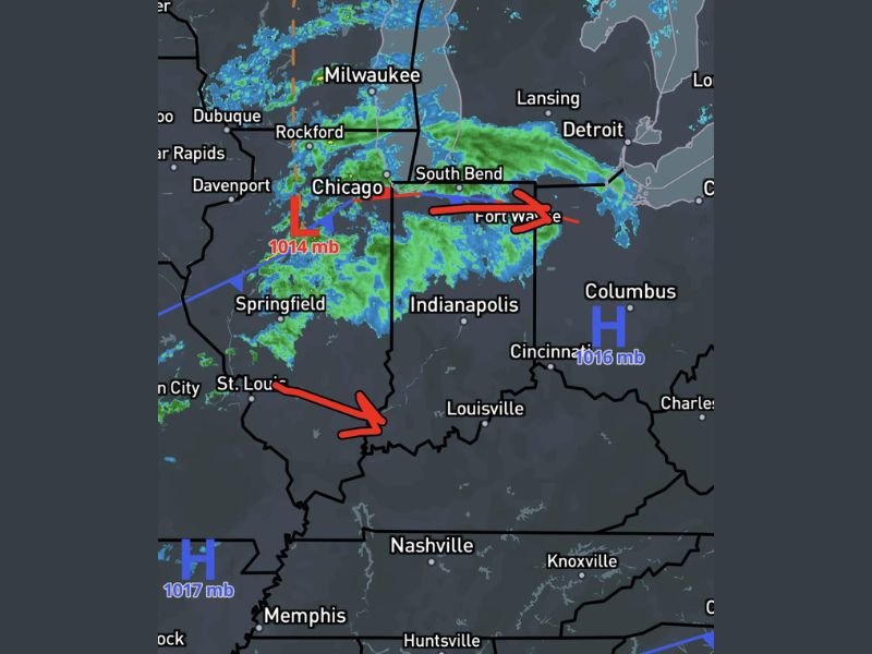
CHICAGO, IL — A new low pressure system centered at 1014 mb near Chicago was pushing rain and a potential wet snow mix across Illinois, Indiana, and Michigan as of 10 PM April 30, 2026, with radar showing widespread precipitation coverage tracking eastward through Chicago, South Bend, Fort Wayne, and Indianapolis as the system ushered in a cold and unsettled start to the month of May.
Behind the departing low pressure system, a couple of chilly mornings and the possibility of frost were expected to settle across the region, making the opening days of May significantly less pleasant than typical spring conditions across the Midwest corridor.
Low Pressure Center Drives Rain and Wet Snow Potential
The 1014 mb low pressure system positioned near Chicago was actively driving precipitation across a wide swath of the Midwest at the time of the 10 PM April 30 radar observation. Radar imagery showed organized precipitation bands pushing eastward through the Chicago, Rockford, South Bend, and Fort Wayne corridor, with the storm system tracking toward Columbus and the broader Ohio Valley region as it continued its eastward progression through the overnight hours.
Wet snow was identified as a possible precipitation type mixing in with rain across northern portions of the affected area, consistent with the cold air wrapping around the back side of the low pressure system and the late season timing of the storm event.
Frost Threat Follows Behind the Departing System
Following the passage of the low pressure system, cold high pressure building into the region behind the front was expected to bring temperatures low enough to support frost formation across portions of the Midwest during the early May morning hours. The combination of clearing skies, light winds, and cold air advection behind the departing system created favorable conditions for surface frost across communities throughout Illinois, Indiana, and surrounding states.
The frost potential added an agricultural concern to an already cold and wet start to May across the region, with sensitive crops and vegetation potentially at risk from the chilly morning temperatures expected in the wake of the low pressure passage.
Widespread Precipitation Covers Illinois and Indiana Corridor
Radar showed extensive green precipitation returns blanketing a broad area from Springfield and St. Louis northward through Chicago and eastward through Indianapolis, Fort Wayne, South Bend, and toward Detroit and the Michigan border. The organized nature of the precipitation bands reflected the well-defined low pressure circulation driving moisture through the region as the system tracked eastward through the Midwest overnight.
Residents across Chicago, Indianapolis, Fort Wayne, South Bend, Columbus, Cincinnati, Louisville, Nashville, and surrounding communities were advised to have rain gear ready for Friday morning and monitor temperatures through the early May weekend as chilly conditions and frost potential followed the departing storm system through the region.
For continuing coverage of weather events and critical storm analysis across the United States, visit SaludaStandard-Sentinel.com.