Dangerous Storms Capable of Strong Tornadoes and Giant Hail to Strike Oklahoma and North Texas This Afternoon With Highest Risk Level 4 of 5 Centered Near Oklahoma City, Tulsa and Dallas
OKLAHOMA — Dangerous storms capable of producing strong tornadoes and giant hail are on the move across Oklahoma and North Texas this afternoon and evening, with the Storm Prediction Center issuing its highest risk level of Level 4 out of 5 for a concentrated zone centered near Oklahoma City and Tulsa. Forecasters are urging residents across the affected areas to identify their safe room immediately and ensure they have multiple ways to receive weather alerts throughout the day and night.
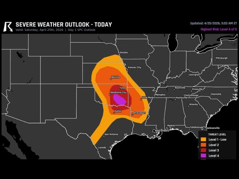
The Severe Weather Outlook, updated at 5:03 AM ET on April 25, 2026, makes clear that this is not a routine storm event — Level 4 is reserved for only the most dangerous and life-threatening severe weather setups.
Where the Highest Risk Is Concentrated
The Level 4 moderate-high risk zone sits directly over a tight area covering Oklahoma City, Tulsa, and extending toward the Oklahoma-Texas border near Dallas. This is where the most dangerous storm activity is expected to be most intense and where the threat for strong tornadoes and giant hail is greatest.
Surrounding that core zone is a Level 3 enhanced risk area covering a broader swath of Oklahoma and extending into portions of Kansas near Wichita to the north and down toward Dallas and Shreveport to the south. A wider Level 1 and Level 2 risk extends across Kansas, Missouri, Arkansas, and Louisiana, indicating that the storm system carries a broad reach even beyond the most dangerous zones.
Primary Threats With These Storms
Two headline dangers accompany this storm system. Strong tornadoes are explicitly called out by forecasters as a primary threat, meaning the atmospheric setup is favorable for tornado development and the potential for significant tornado tracks across the warned area. Giant hail is the second major hazard, with storm cells capable of producing hailstones large enough to cause serious damage to vehicles, rooftops, and anyone caught outdoors.
Any storm that develops within the Level 4 zone today should be treated as an immediate life-threatening event. Residents should not wait for a tornado warning to be issued before moving to their safe room if they are in the highest risk area.
What Residents Must Do Right Now
Forecasters are giving direct and urgent guidance to everyone across Oklahoma and North Texas today. Identify your safe room before storms arrive. An interior room on the lowest floor of a sturdy building away from all windows is the safest option. Ensure you have multiple ways to receive weather alerts — do not rely on a single source. Phone alerts, weather radio, and local broadcasts should all be active and within reach throughout the afternoon and into the night.
Do not assume the storm will miss your location. With a Level 4 risk in place, the threat is significant enough that preparation should be treated as mandatory rather than optional.
Stay connected and share your storm reports from Oklahoma and North Texas at SaludaStandard-Sentinel.com.