Scattered Showers, Lightning and Gusty Winds to Impact Alabama This Weekend With No Organized Severe Weather Expected, Stronger Storms With Tornado Risk Possible
ALABAMA — A wet but manageable weekend is shaping up across Alabama, with scattered showers and storms possible each day while forecasters maintain that no organized severe weather is expected during the Saturday and Sunday timeframe. Residents can expect plenty of dry windows throughout the weekend, but meteorologists are urging people not to let their guard down entirely as any storm that does develop will be capable of producing lightning, gusty winds, and brief heavy downpours.
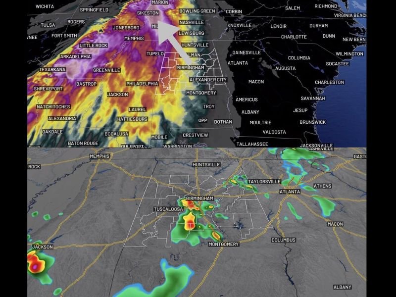
The strongest storm activity over the past 24 hours remained concentrated in West Alabama, with guidance suggesting another batch could brush southwest areas early Saturday morning.
Weekend Storm Outlook and Talladega Race Impact
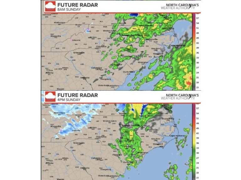
Future radar projections show scattered storm activity developing across the Birmingham and Tuscaloosa corridor during Saturday afternoon, with additional coverage spreading across central Alabama into Sunday morning and afternoon. Sunday’s radar outlook shows a more widespread rain signal pushing through the region by mid-morning before a second round develops by Sunday afternoon across portions of central and southern Alabama.
For race fans heading to Talladega this weekend, forecasters expect some good breaks in the weather during race time, but isolated afternoon pop-up storms cannot be completely ruled out. Anyone attending the event should have a plan in place in case thunder moves nearby, as lightning safety protocols could impact race operations.
Monday and Tuesday Bring a More Serious Threat
The more significant weather concern for Alabama arrives early next week. While the overall trend has shown some improvement, forecasters are continuing to monitor the possibility of stronger storms drifting south into the region by Tuesday. Late Monday night through Tuesday is being highlighted as the window when a few stronger storms could impact the area.
The greatest tornado risk associated with this system is expected to remain northwest of Alabama, but the potential for storms carrying that energy to drift southward keeps Tuesday in focus. Residents across north and central Alabama in particular should stay weather aware heading into the early part of next week and monitor updated forecasts as new data becomes available throughout the weekend.
Rain Welcome but Not a Drought Buster
While the weekend rain is unlikely to make a significant dent in ongoing dry conditions across the region, forecasters note that every drop counts and more rain chances are on the way heading into next week. The rainfall from this weekend event represents a start rather than a solution, with additional precipitation opportunities expected to develop as the next system approaches.
Residents are encouraged to stay connected to updated forecasts through Saturday morning and beyond as timing and coverage details continue to be refined.
Share your Alabama storm reports and weekend weather observations with the community at SaludaStandard-Sentinel.com.