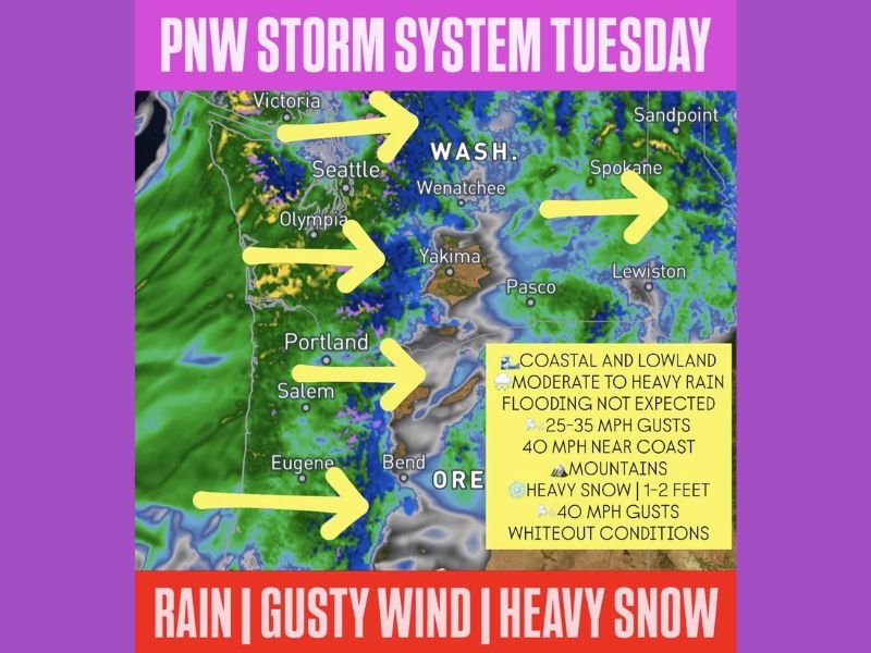
Pacific Northwest Braces for Powerful Tuesday Storm Bringing Heavy Mountain Snow Up to 2 Feet, 40 MPH Coastal Gusts and Whiteout Conditions Across Washington and Oregon
WASHINGTON AND OREGON — Enjoy the quiet on Monday across the Pacific Northwest because Tuesday is going to be a completely different story. A strong Pacific front and low pressure system are approaching and will deliver significant and disruptive weather throughout the day Tuesday across Washington and Oregon.
Heavy mountain snow reaching 1 to 2 feet, gusty winds up to 40 MPH near the coast, moderate to heavy lowland rain, and whiteout conditions across mountain passes will all make Tuesday one of the most impactful weather days the region has seen this spring.
Coastal and Lowland Areas Hit With Rain and Gusty Winds
Across coastal and lowland areas of Washington and Oregon, the incoming Pacific front will bring moderate to heavy rainfall throughout Tuesday as the system pushes onshore and tracks eastward. Communities including Seattle, Olympia, Portland, Salem, and Eugene will all experience breezy and wet conditions as the front moves through during the day.
Wind gusts of 25 to 35 MPH are expected across inland lowland areas, with gusts ramping up to 40 MPH near the coast. While flooding is not expected across the lowlands with this system, the combination of heavy rain and gusty winds will create hazardous driving conditions and make any outdoor activities extremely unpleasant and potentially dangerous throughout the day.
Mountains Facing 1 to 2 Feet of Heavy Snow and Whiteout Conditions
The most dangerous and dramatic impacts from Tuesday’s Pacific storm will be felt across the mountain passes of Washington and Oregon. Heavy snow accumulations of 1 to 2 feet are forecast for mountain elevations, accompanied by 40 MPH wind gusts that will create blowing and drifting snow leading to whiteout conditions across the passes.
Pass travel is expected to become difficult to impossible by Tuesday night as snow accumulates rapidly and visibility drops to near zero across mountain highway corridors. Anyone planning to travel through mountain passes in Washington or Oregon on Tuesday should strongly reconsider their plans or complete their travel before conditions deteriorate.
Spokane, Wenatchee and Eastern Washington Also in the Storm’s Path
The storm system will not stop at the Cascades. Eastern Washington communities including Spokane, Wenatchee, Yakima, Pasco, and Lewiston will also feel the effects of the incoming Pacific front as it pushes through the region. Residents across eastern Washington and into northern Idaho near Sandpoint should prepare for changing and potentially impactful weather conditions as the system tracks eastward Tuesday.
Monday remains quiet and calm across the Pacific Northwest, making it the ideal day to complete any essential travel, errands, or outdoor tasks before Tuesday’s storm arrives in full force. Stay weather aware and informed at SaludaStandard-Sentinel.com.