North Carolina Drought Worsens as Zero Rain Expected for 7 Days With 90 Degree April Heatwave and High Fire Danger Threatening the Entire State This Week
NORTH CAROLINA — If you were hoping for rain this week across North Carolina, the forecast is delivering nothing but disappointment and danger. Little to no rainfall is expected across most of the state over the next seven days, and the situation is far more serious than a simple dry stretch. Most of North Carolina is already locked in drought conditions, the growing season is fully underway, and a mini April heatwave with temperatures surging into the 90s is about to make everything dramatically worse.
No Meaningful Rain Expected Through Next Sunday
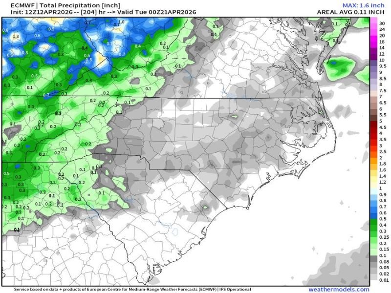
The European forecast model through Tuesday April 21, 2026 is showing a devastating picture for North Carolina. The vast majority of the state is painted in gray across the precipitation outlook, indicating little to no rainfall expected through the entire period. While some areas along the western mountains and far northwestern corner of the state may see trace amounts approaching 0.1 to 0.3 inches, the rest of North Carolina is essentially bone dry on the map.
The areal average precipitation forecast for the entire region through this period is just 0.11 inches, a number that will do virtually nothing for drought-stressed soils, crops, and water supplies already running critically low heading into the heart of spring.
Mini April Heatwave Pushing Temperatures Into the 90s
Compounding the rain drought is a mini April heatwave that is bringing several days of 90 degree temperatures to many parts of North Carolina this week. The heat arriving alongside the dry conditions means soil moisture will evaporate even faster, crops will experience additional stress, and wildfire fuel across the landscape will continue drying out to dangerous levels.
The heat this week is described as a drier heat with limited humidity, meaning the typical coastal humidity that sometimes tempers North Carolina’s warmth will be largely absent. That combination of extreme heat and low humidity is a dangerous recipe for rapid fire spread across any area that sees ignition.
High Fire Danger Persisting All Week Across North Carolina
With drought conditions intensifying, temperatures in the 90s, low humidity, and no rain on the horizon, high fire danger will persist across North Carolina for the entire week ahead. Any fire that starts under these conditions will spread rapidly and be extremely difficult for firefighters to contain.
Residents are being urged in the strongest possible terms to avoid any outdoor burning activity this week without exception. An isolated thunderstorm is possible in the mountains late in the week, but that slim chance will not arrive soon enough or deliver enough rainfall to meaningfully reduce the fire danger. Stay weather aware and stay informed at SaludaStandard-Sentinel.com.