Tornado Outbreak Threat Erupts Across Southern Minnesota Into Wisconsin Monday Afternoon as Dangerous Supercells Fire After 4 PM With 60 Degree Dewpoints Fueling the Violence
MINNESOTA AND WISCONSIN — A big-time tornado threat is locked and loaded for Monday afternoon and evening across southern Minnesota and into Wisconsin, with forecasters warning that a possible tornado outbreak is on the table for the Upper Midwest region.
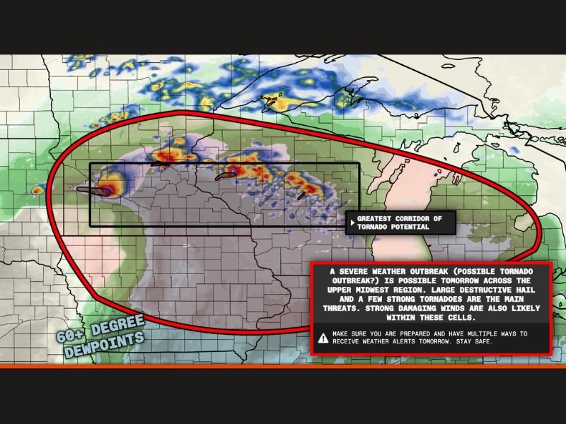
Supercells are expected to erupt by 4 PM and develop tornado potential rapidly, fueled by explosive 60 degree plus dewpoints that will supercharge any storm that manages to fire across the greatest corridor of tornado potential identified on today’s models.
Supercells Erupting by 4 PM Along the Warm Front
The setup for Monday’s tornado threat is being driven by a powerful warm front pushing across southern Minnesota and into Wisconsin. Supercells are forecast to fire explosively along this warm frontal boundary beginning around 4 PM, and once they develop they are expected to quickly acquire tornado potential in an environment primed for violent and long-track tornadoes.
The HRRR model simulated reflectivity clearly shows the greatest corridor of tornado potential concentrated along a corridor stretching from southern Minnesota directly into Wisconsin. Every community within this target zone needs to treat Monday afternoon as a potentially life-threatening severe weather event from the moment storms begin firing.
60 Degree Dewpoints Are the Most Alarming Detail in This Setup
Perhaps the single most alarming ingredient in Monday’s severe weather setup is the presence of 60 degree plus dewpoints across the target area. Dewpoints at this level in April represent an exceptionally moist and unstable atmosphere that will provide massive amounts of energy to any supercell that develops along the warm front.
When storms tap into this level of atmospheric moisture combined with the strong wind shear already in place, the conditions become favorable not just for tornadoes but for large destructive hail and strong damaging winds simultaneously. Every hazard is on the table across this corridor Monday evening.
Large Hail, Damaging Winds and Strong Tornadoes All Possible
The primary hazards forecast for Monday’s severe weather outbreak across the Upper Midwest are large destructive hail, strong damaging winds, and a few strong tornadoes within the most intense supercells. All of these threats will be possible simultaneously within the same storm cells, meaning residents may face multiple life-threatening dangers from a single storm passing over their location.
Residents across southern Minnesota and Wisconsin must have multiple ways to receive weather alerts on Monday. Do not rely on outdoor sirens alone. A weather radio, a smartphone with alerts enabled, and knowledge of your nearest shelter location are all essential before 4 PM arrives.
Do not wait until storms are on top of you to act. Prepare now. Stay weather aware and follow updates at SaludaStandard-Sentinel.com.