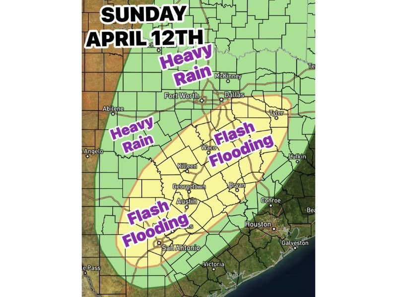
Two Rounds of Heavy Rain, Flash Flooding and Severe Storms to Slam Central and South Texas This Sunday April 12
TEXAS — A significant and multi-layered storm threat is unfolding across Texas this Sunday, April 12, as forecasters warn of two separate and dangerous rounds of severe weather capable of producing heavy rainfall, flash flooding, large hail, damaging winds, and an isolated tornado risk across Central and South Texas.
Residents from the Abilene corridor down through San Antonio, Austin, Houston, and surrounding communities are being urged to remain weather-aware throughout the entire day and into the evening hours.
Storms Forming Off the Dry Line in Far West Texas
The severe weather setup begins with storms developing off the dry line in far West Texas during the afternoon hours. These storms are expected to push eastward through the region, with showers and thunderstorms forecast to reach the Abilene line by midnight Saturday night into Sunday morning.
The arrival of this initial activity sets the stage for what forecasters are describing as a two-round event, with each round carrying its own distinct threats and impacted areas across the state.
Round One: 6 AM to 10 AM — Weakening Storms Enter North Central Texas
The first round of storms is expected to arrive across North Central Texas between 6 AM and 10 AM Sunday morning. At this stage, storm activity is forecast to be in a weakening phase as it pushes into the region, bringing pockets of moderate to heavy rainfall at times.
Gusty winds and lightning will accompany this round, though forecasters currently classify this portion of the event as non-severe. Residents should still exercise caution during morning travel, as wet roads and reduced visibility can create hazardous driving conditions even with non-severe storm activity.
Round Two: 3 PM to 9 PM — The Most Dangerous Window of the Day
The second and far more dangerous round is forecast to develop between 3 PM and 9 PM Sunday afternoon and evening. Morning storm activity is expected to kick out an outflow boundary for areas south of Interstate 20, and that boundary will serve as the primary focal point for afternoon storm redevelopment across Central and South Texas.
Water content values are forecast to reach 1.75 inches per hour during this round, a level sufficient to support isolated flash flooding across vulnerable areas. This makes the afternoon and evening hours the most critical window for life-threatening weather across the region.
Flash Flooding Threat Covers Wide Area From Austin to Houston
The flash flooding risk during Sunday’s second round is particularly serious across a broad zone that includes communities such as Waco, Killeen, Georgetown, Austin, Bryan, Conroe, Houston, San Antonio, and Victoria. Forecasters have highlighted this swath of Central and South Texas as the area most likely to see rapid water rises in low-lying areas, roadways, and drainage systems.
Residents in flood-prone neighborhoods are urged to avoid driving through standing or moving water and to monitor local emergency alerts closely. Even a small amount of fast-moving water is capable of sweeping vehicles off roadways.
Severe Storm Risk South of I-20 Includes Hail, Wind and Tornado Threat
Beyond the flooding danger, the afternoon redevelopment south of I-20 also brings a heightened severe storm threat. Large hail, damaging winds, and an isolated tornado risk are all on the table for the favored storm development zone during the 3 PM to 9 PM timeframe.
Communities including Tyler, Lufkin, and areas across South and Central Texas fall within this elevated risk corridor. Residents should have multiple ways to receive emergency alerts and should know where to take shelter in the event a tornado warning is issued for their county.
What Residents Should Do Before Sunday Arrives
Ahead of Sunday’s storm system, forecasters and emergency management officials recommend that residents across affected areas review their emergency plans, charge mobile devices, and avoid unnecessary travel during the peak afternoon and evening hours. Those in areas prone to flash flooding should move vehicles to higher ground and keep important documents and medications readily accessible.
Staying connected to local weather broadcasts and alert systems throughout the day will be critical as storm conditions evolve rapidly across the region on Sunday.
Have you experienced severe weather in your area this weekend? Share your reports and stay safe by following updates at SaludaStandard-Sentinel.com.