Alabama Faces Prolonged Dry Weather Pattern With 80s to Low 90s Heat Expected Next Week and Limited Rainfall Through Mid April
ALABAMA — An extended stretch of dry weather is expected to continue across Alabama through next week, with rising temperatures pushing into the 80s and even low 90s in some areas. The pattern is being driven by a strong upper-level ridge, keeping rain systems away from the region.
Forecasters say the setup will bring consistent sunshine, warmer afternoons, and limited chances for rainfall across much of the state.
Upper Ridge Keeps Rain Systems Away From Alabama
The dominant weather feature behind this pattern is a high-pressure ridge positioned over the region. This system is effectively blocking typical storm tracks, keeping most rain-producing systems to the west and north.
As a result, Alabama is expected to experience mostly dry conditions for an extended period. Skies will remain partly to mostly sunny, with calm and stable weather dominating both daytime and nighttime hours. This type of setup can persist for several days, leading to gradually intensifying warmth.
Temperatures Climb Into 80s and Approach 90 Degrees
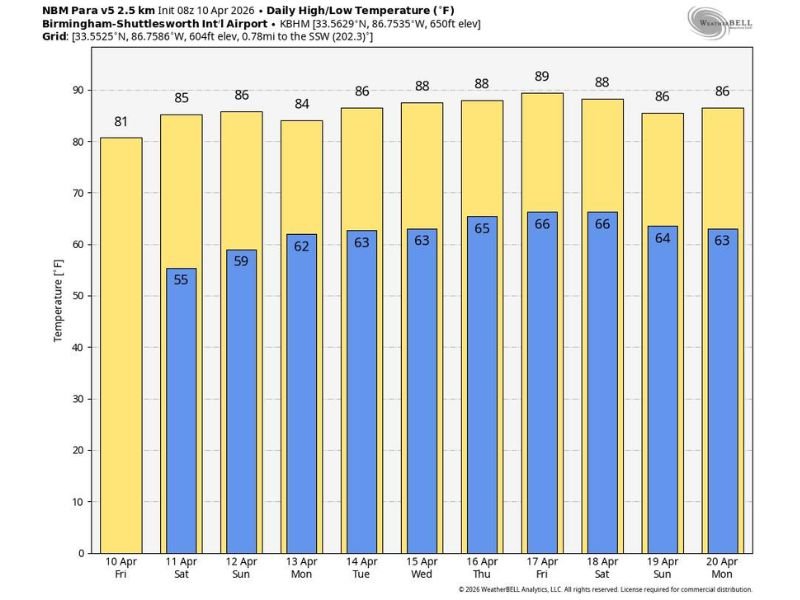
Afternoon highs are forecast to steadily rise into the 80s across much of Alabama, with some southern communities potentially reaching the low 90s by the latter part of next week.
Data shows a warming trend beginning with highs in the low 80s and climbing toward the upper 80s by mid to late week. Overnight lows will also increase, moving from the mid-50s into the mid-60s. This gradual warming trend signals a shift toward early summer-like conditions.
Extended Dry Spell Raises Concerns Over Soil Moisture
With little to no rainfall expected in the near term, the extended dry pattern could begin to impact soil moisture levels. Continued sunshine and rising temperatures may accelerate drying across fields and landscapes.
While drought conditions are not yet confirmed, prolonged dryness can increase the risk if the pattern continues beyond next week. Residents and agricultural communities may begin to notice the effects if rainfall remains limited.
Rain Chances May Return Later in April
Looking ahead, longer-range forecast models suggest a possible shift in the pattern during the week of April 20 through April 24. During this time, a few chances for rainfall could return to the region.
However, confidence in the timing and coverage of these rain chances remains uncertain. Until then, dry conditions are expected to dominate. Residents are advised to monitor forecast updates as the pattern evolves.
Warm and Dry Pattern Signals Early Seasonal Shift
The combination of sustained warmth and lack of rainfall is a clear sign of a seasonal transition toward summer-like weather. While pleasant for outdoor plans, the pattern also carries potential downsides if it persists too long.
Officials recommend staying aware of changing conditions, especially as temperatures rise and moisture levels drop. If you’re noticing the dry conditions or rising heat in your area, share your experience with us at SaludaStandard-Sentinel.com.