Texas, Oklahoma, Kansas and Arkansas Face Multi Day Severe Storm Threat With Overlapping Risk Zones Signaling Repeated Hail, Wind and Tornado Potential
UNITED STATES — A multi-day severe weather pattern is taking shape across the central United States, with overlapping risk zones signaling the potential for repeated rounds of storms over the next seven days.
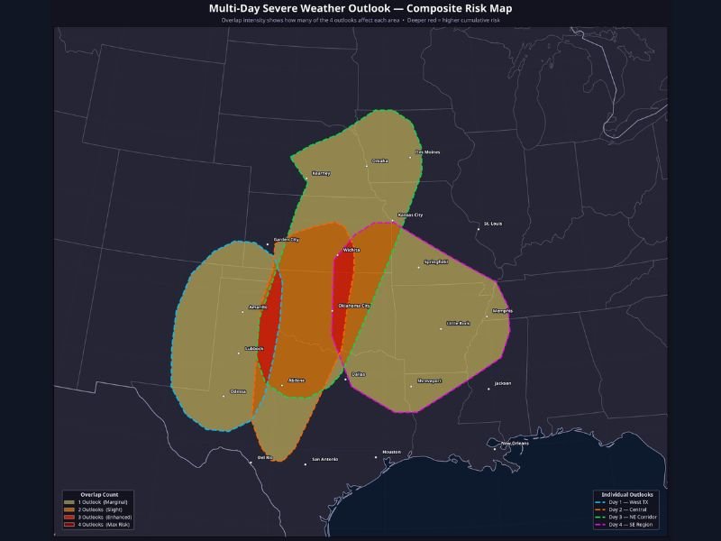
The latest composite outlook highlights a broad corridor stretching from Texas through Oklahoma and into Kansas, with additional risk extending eastward into Arkansas and parts of the Lower Mississippi Valley. The overlapping nature of these forecasts suggests that some areas could face multiple rounds of severe weather rather than a single isolated event.
Overlapping Risk Zones Increase Concern for Repeated Storm Impacts
The composite map shows several layers of severe weather outlooks stacked across the same regions, particularly from north Texas through central Oklahoma into southern Kansas.
This overlap indicates that multiple storm systems are expected to track across similar areas over consecutive days. As a result, communities in these zones may experience repeated impacts, including heavy rain, strong winds, and severe thunderstorms.
The highest concentration of overlapping risk appears centered near Oklahoma City and extending north toward Wichita, where conditions may align for stronger and more persistent storm activity.
Core Severe Corridor Runs From Texas to Kansas
A defined corridor of heightened concern stretches from parts of west and north Texas through Oklahoma and into Kansas. Cities such as Dallas, Abilene, Oklahoma City, and Wichita lie within or near this central zone.
Within this corridor, the potential exists for organized storm systems capable of producing large hail and damaging winds. The repeated nature of these storms could also increase the risk of localized flooding, especially in areas that receive multiple rounds of rainfall. This central corridor represents the most consistent area of concern throughout the multi-day period.
Eastern Expansion Brings Risk Into Arkansas and Mississippi Valley
In addition to the central Plains, the risk area expands eastward into Arkansas and portions of the Lower Mississippi Valley, including areas near Memphis.
While the overlap in this region is slightly less intense, it still indicates a continued threat for severe weather as storm systems progress eastward.
Communities in these areas could see storms later in the sequence, bringing similar hazards including gusty winds and possible severe thunderstorms.
Western Zones Also See Storm Potential Across Texas Panhandle
The outlook also includes parts of the Texas Panhandle and surrounding western regions, where isolated to scattered severe storms are possible.
Although these areas may not see the same level of overlap as the central corridor, they remain within the broader risk zone and could experience strong storms during certain periods.
Cities such as Amarillo and Lubbock fall within this western extension, where storm development may be more sporadic but still impactful.
Multi Day Pattern Signals Active Severe Weather Stretch Ahead
The key takeaway from this outlook is not just the presence of severe weather, but the duration and repetition of the threat. Multiple storm systems moving through the same general region increase the likelihood of cumulative impacts.
This type of pattern can strain infrastructure, particularly if heavy rainfall leads to flooding or if repeated wind events cause damage over time.
Residents across Texas, Oklahoma, Kansas, and Arkansas are encouraged to stay alert throughout the week, as conditions may change from day to day while the overall threat remains elevated.
If your area is included in this multi-day risk zone, share what you’re seeing and stay connected with updates at SaludaStandard-Sentinel.com.