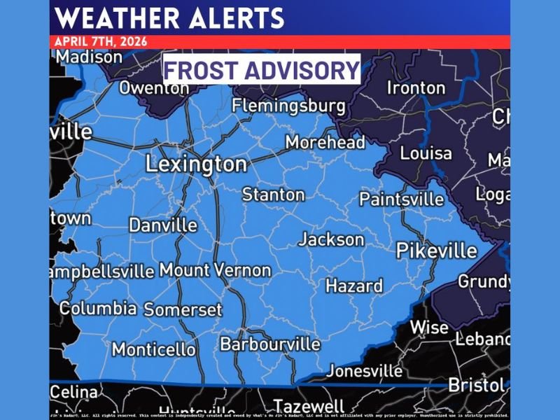
Kentucky Frost Advisory Covers Lexington, Pikeville, Somerset and Eastern Counties as Temperatures Drop Into Tuesday Morning
KENTUCKY — A widespread frost advisory has been issued across central and eastern Kentucky, including Lexington, Pikeville, Somerset, and surrounding communities, as temperatures are expected to drop significantly early Tuesday morning.
The advisory highlights the risk of frost formation across a large portion of the state, with colder overnight conditions creating concern for sensitive vegetation and early spring crops.
Frost Advisory Spans Central and Eastern Kentucky
The advisory area covers a broad stretch of Kentucky, including major cities such as Lexington, Morehead, Jackson, Hazard, Pikeville, Somerset, and Mount Vernon. Rural communities and valleys across eastern Kentucky are especially vulnerable, where colder air tends to settle overnight.
Weather data indicates that temperatures will fall to near or below freezing in many of these locations, creating ideal conditions for frost to develop before sunrise Tuesday.
This type of setup is common during early April, when warmer daytime temperatures are followed by sharp nighttime cooling under clear skies.
Why Frost Is Expected Tuesday Morning
The primary driver behind this frost event is a combination of clear skies, light winds, and a cooler air mass moving into the region. These conditions allow heat to escape rapidly from the surface overnight, leading to significant temperature drops.
As temperatures fall into the mid-30s or lower, moisture near the ground can freeze on surfaces, forming frost. This is especially likely in low-lying areas and locations away from urban heat sources. Even areas that remain just above freezing can still experience patchy frost, particularly on exposed surfaces.
Impacts on Agriculture and Outdoor Plants
The timing of this frost advisory is critical, as many areas across Kentucky have already begun their spring growing season. Early blooming plants, gardens, and crops may be at risk if left unprotected.
Frost can damage or kill sensitive vegetation, especially if temperatures remain low for several hours. Farmers and gardeners are advised to take precautions such as covering plants or bringing potted vegetation indoors where possible. Fruit trees and budding crops could also be affected if temperatures drop lower than currently expected.
Cold Pattern Continues Into Early Week
This frost advisory follows a recent shift toward cooler conditions across the region. While daytime temperatures may recover slightly, overnight lows are expected to remain chilly in the short term.
The persistence of cooler air suggests that additional cold mornings may be possible, though the most widespread frost risk currently appears focused on Tuesday morning.
Residents should remain aware of updated forecasts, as slight changes in temperature could expand or reduce the affected area.
What Residents Should Do Now
With frost expected early Tuesday, residents across central and eastern Kentucky are encouraged to prepare ahead of time. Protecting plants, checking outdoor water systems, and planning for colder morning conditions can help reduce potential impacts.
Drivers should also be aware that frost can occasionally lead to slick spots on bridges and elevated surfaces during early morning hours, although widespread travel impacts are not expected at this time.
As conditions continue to evolve, staying informed will be important for those living across the advisory area. Have you already started planting this spring in Kentucky? Share how you’re preparing for the cold snap and join the conversation at SaludaStandard-Sentinel.com.