Mississippi and Alabama See Rain Line Push East From Jackson and Hattiesburg Toward Birmingham and Montgomery Bringing Best Rain Chance in Days
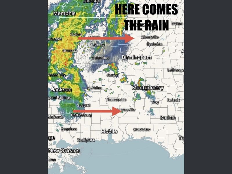
MISSISSIPPI AND ALABAMA — A broad area of rain and embedded storms is pushing eastward from Mississippi into Alabama this evening, marking what could be the most significant chance of rainfall the region has seen in several days.
The system, currently stretching from areas near Jackson and Grenada down toward Hattiesburg, is steadily advancing toward central and eastern Alabama, including cities such as Birmingham and Montgomery.
Rain Band Expands East Across Mississippi Into Alabama
Radar imagery shows a large, organized band of rain covering much of western Mississippi, with heavier pockets of rainfall embedded within the system. This rain shield is gradually moving east, crossing into Alabama as the evening progresses.
Communities in eastern Mississippi, including areas near Columbus and Meridian, are beginning to see increasing cloud cover and scattered showers ahead of the main rain line.
Heavier Rainfall and Gusty Storms Possible
While the overall severe weather risk remains low, some of the storms embedded within the rain band could produce gusty winds and brief heavier downpours.
These stronger pockets are most likely to develop along the leading edge of the rain as it moves into Alabama, particularly in areas west of Birmingham and Montgomery.
Best Rain Chance in Several Days for the Region
This system represents one of the better opportunities for measurable rainfall across parts of Mississippi and Alabama in recent days. Many locations have been waiting for a more consistent rain event, and this system is expected to deliver that.
Rain coverage is expected to increase through the evening hours, gradually spreading from west to east across the region.
Storms Continue Tracking East Into Central Alabama Tonight
As the system progresses, areas including Birmingham, Montgomery, and surrounding communities will likely see rain move in later this evening.
The west-to-east movement means western Alabama will see impacts first, followed by central and eventually eastern portions of the state overnight.
Conditions Expected to Remain Manageable Despite Storm Activity
Even with widespread rain, the overall setup does not currently favor a major severe weather event. However, residents should remain aware of changing conditions, especially where heavier downpours or gusty winds develop.
Localized impacts such as brief ponding on roads or reduced visibility may still occur during the heaviest rainfall periods. If you’re seeing rain move into your area tonight, share your conditions with us at SaludaStandard-Sentinel.com and help others track how the system is progressing.