Kansas, Nebraska, Iowa, South Dakota and Missouri Could See Major Snow Band Shift South With 6 to 10 Inches Possible in Latest Model Trend
UNITED STATES — A notable shift in forecast models is pointing toward a more southern track for an incoming snow band, potentially bringing significant snowfall to parts of Kansas, Nebraska, Iowa, South Dakota, and Missouri.
The latest guidance suggests that areas previously expected to see lighter impacts could now fall directly in the path of heavier snow totals.
Snow Band Trending South Across Central Plains
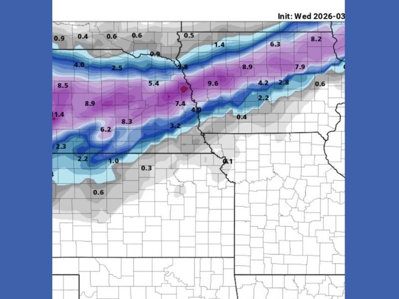
Recent model trends indicate the core of the snow band is shifting southward, placing a corridor from Kansas through Nebraska and into Iowa in a more favorable position for heavier snowfall.
This adjustment changes the outlook for several states, as areas closer to the southern edge of the system may now experience more impactful conditions than earlier projections suggested. The band appears well-defined, with a concentrated zone of higher totals stretching across multiple states.
Heaviest Snow Potential Focused Near Nebraska and Iowa
The highest snowfall totals are projected across parts of Nebraska and Iowa, where model data suggests accumulations could reach between 6 and 10 inches in localized areas.
This zone represents the core of the system, where moisture and atmospheric dynamics align most effectively to produce sustained snowfall.
Cities and rural areas within this corridor could see rapid accumulation rates, especially if the band remains stationary for several hours.
Kansas and Missouri Could See Expanding Snow Impacts
With the southward shift, parts of northern Kansas and northern Missouri are now more likely to see measurable snowfall. While totals in these areas may vary, the potential for impactful accumulation has increased.
This change could affect travel conditions, particularly along major routes connecting these states to the central Midwest. Drivers should be aware that even modest snowfall can lead to hazardous road conditions, especially if temperatures remain low.
South Dakota Also Included on Northern Edge of System
On the northern side of the system, portions of South Dakota remain within the broader snow zone. While totals here may be less consistent, the state still falls within the overall impact area. This highlights the wide reach of the system, spanning multiple regions with varying snowfall intensities.
Forecast Uncertainty Remains Despite Strong Model Signal
While confidence is growing in the southward trend, some uncertainty remains regarding the exact placement of the heaviest snow band. Small shifts in the track could still alter which areas see the highest totals.
Forecast updates over the coming hours will be critical in refining the expected impact zones and snowfall amounts.
Residents across the central Plains and Midwest are encouraged to stay updated and prepare for potential winter weather conditions.
If you’re in Kansas, Nebraska, Iowa, South Dakota, or Missouri, share what conditions look like in your area by visiting SaludaStandard-Sentinel.com.