Texas, Oklahoma, Arkansas, Louisiana and Mississippi Could See Rain Return March 31 Into April 1 After Prolonged Heat and Dry Stretch
UNITED STATES — After an extended stretch of hot and dry weather, new forecast data is signaling a potential pattern shift that could bring scattered rainfall back to parts of the Southern Plains and Gulf Coast by the end of March.
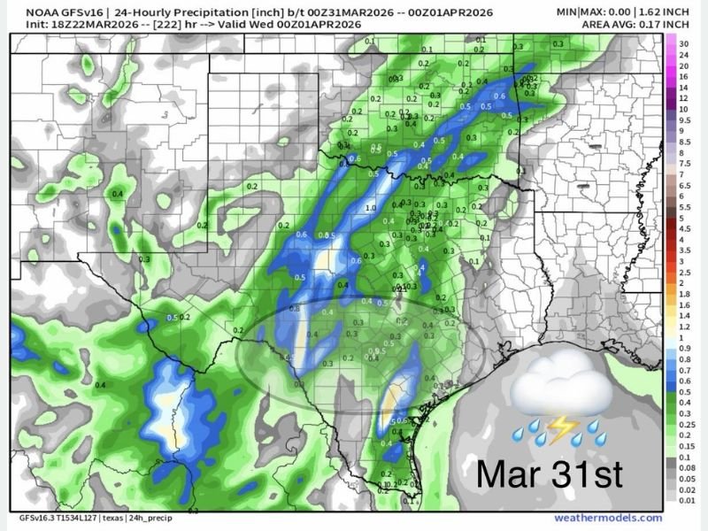
The latest model guidance highlights increasing rain chances beginning around March 31 and continuing into early April 1, offering possible relief for areas that have seen limited precipitation in recent days.
Rain Signals Begin to Show in Forecast Models
According to recent projections, a developing system may bring scattered showers across a broad region stretching from Texas through Oklahoma, Arkansas, Louisiana, and into parts of Mississippi.
While totals are not expected to be extreme at this stage, the presence of widespread light to moderate rainfall signals a meaningful change in the overall weather pattern.
Forecast maps indicate pockets of higher rainfall potential, particularly across eastern Texas and into surrounding states, where localized heavier bands could develop.
A Shift After Persistent Heat and Dry Conditions
This potential rain event follows what has been described as a “brutally hot stretch” across parts of the region.
High temperatures and dry air have dominated much of the Southern Plains, increasing concerns about drought conditions and fire risk in some areas.
The return of even scattered precipitation could help ease some of those concerns, especially if additional systems follow into early April.
Timing Still Developing but Pattern Change Clear
Meteorologists caution that while the signal for rain is becoming clearer, exact timing and rainfall totals remain uncertain due to the long-range nature of the forecast.
The current outlook suggests activity beginning late March 31 and continuing into April 1, but details such as storm intensity, coverage, and exact placement will become clearer in the coming days.
What is more certain, however, is the broader shift in atmospheric patterns that is allowing moisture to return to the region.
What This Means for the Southeast and Beyond
As this system develops, it may also influence weather further east, potentially bringing cloud cover and scattered showers into parts of the Deep South.
States like Mississippi and possibly Alabama could see impacts depending on how the system evolves and tracks.
This could mark the beginning of a more active weather pattern heading into early April, replacing the recent stretch of dry and unusually warm conditions.
Looking Ahead to Early April
If current trends continue, this system may not be a one-time event. The developing pattern suggests additional opportunities for rainfall could follow, which would be beneficial for areas currently experiencing dryness.
Residents should stay alert for forecast updates as the timing and intensity of this system become clearer.
Have you been experiencing the recent heat and dry conditions in your area? Share your thoughts and stay connected with ongoing coverage at SaludaStandard-Sentinel.com.