Mississippi and Alabama Tornado Watch Expanded Into Southwest Counties Until 2 A.M. as Storm Line Brings Damaging Winds, Hail, and Isolated Tornado Risk
MISSISSIPPI & ALABAMA — A tornado watch has been expanded to include several southwest counties across parts of Mississippi and Alabama as a powerful line of thunderstorms moves south Wednesday evening. The watch remains in effect until 2 a.m. Thursday, with meteorologists warning that storms may produce damaging wind gusts, hail, and a few isolated tornadoes overnight.
Weather experts say the expanding threat comes as an outflow boundary from earlier storms pushes southward, shifting the zone of instability deeper into the region. As that boundary moves, the risk of severe weather — including tornado development — is expected to move south with it.
Strong Storm Line Moving Across the Region
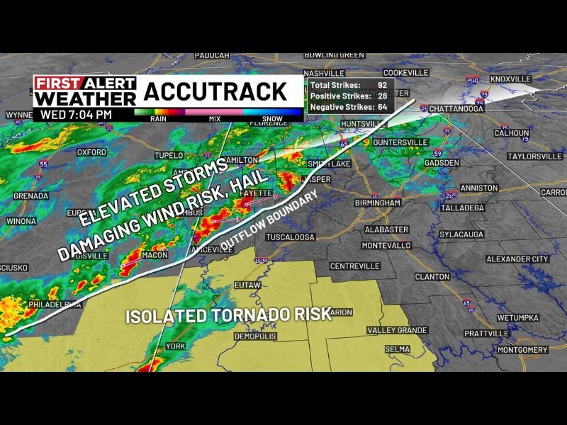
Radar imagery Wednesday evening showed a well-organized line of storms stretching across parts of Mississippi and Alabama, with clusters of intense thunderstorms embedded within the line.
These storms are capable of producing strong wind gusts and bursts of heavy rainfall, which could create dangerous travel conditions and localized power outages. Communities along the storm path may experience rapid weather changes, including sudden wind surges and lightning as the system pushes through the region.
Damaging Wind and Hail the Main Threats
Meteorologists say the primary severe weather hazard will likely be damaging winds, as the line of storms continues to strengthen in places. Some storms could also produce hail, particularly within the stronger thunderstorm cores. Wind gusts strong enough to knock down tree limbs and power lines remain possible overnight. Drivers traveling during the late evening hours are advised to remain cautious, as heavy rain and gusty winds may reduce visibility and create hazardous road conditions.
Isolated Tornado Risk Developing Along Boundary
Forecasters say the outflow boundary moving south is creating an environment where storms may briefly rotate, raising the potential for isolated tornadoes.
This type of setup can produce quick spin-up tornadoes embedded within the larger storm line, which can develop rapidly and with little warning. Because of this possibility, meteorologists expanded the tornado watch to include more southwest counties across the region.
Watch Area Could Be Adjusted Later Tonight
Weather officials say the tornado watch currently runs until 2 a.m., but the coverage area could change depending on how storms evolve overnight.
If storms weaken or move out of certain counties earlier than expected, parts of the watch area could be trimmed before midnight. However, forecasters stress that residents across the region should remain weather aware until the system fully clears the area.
Residents Urged to Stay Alert During Overnight Storms
Overnight severe weather events can be especially dangerous because many people may be asleep when warnings are issued.
Meteorologists encourage residents across Mississippi and Alabama to enable emergency alerts on mobile devices and keep weather radios active in case tornado warnings are issued. Officials also advise identifying a safe shelter location in homes — preferably an interior room away from windows — if severe storms intensify overnight.
Forecasters will continue monitoring the storm system as it moves farther south through the night. Stay with Saluda Standard-Sentinel for continued updates as severe weather develops across Mississippi, Alabama, and the Gulf Coast region.