Strong Thunderstorm Moves Over St. Petersburg, Florida as Radar Shows Intense Lightning and Possible Small Hail Friday Night
FLORIDA — A strong thunderstorm moved directly over St. Petersburg Friday evening, producing intense rainfall, frequent lightning, and the possibility of small hail as the storm tracked across the Tampa Bay region.
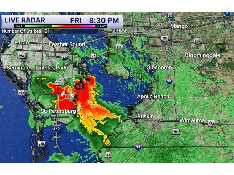
Radar imagery around 8:30–8:53 PM showed a concentrated storm cell centered over St. Petersburg with heavy precipitation and strong thunderstorm activity. Meteorologists monitoring the storm noted that it was moving toward the west-northwest, pushing across parts of Pinellas County and surrounding coastal areas.
The storm quickly intensified as it moved through the region, with radar indicating a dense core of heavy rain accompanied by significant lightning activity across the Tampa Bay area.
Radar Shows Intense Storm Core Over St. Petersburg
Live radar scans from the Tampa Bay area revealed a bright red and orange storm core positioned directly over St. Petersburg, a typical indicator of extremely heavy rainfall within a thunderstorm.
The storm appeared to stretch from the southern portion of the city toward nearby waterways and coastal neighborhoods. Lightning strikes were also detected within the storm, suggesting strong updrafts and active thunderstorm development.
Meteorologists observed at least 21 lightning strikes associated with the storm cell during the radar scan, highlighting the intensity of the thunderstorm as it moved through the region.
Residents in nearby communities such as Pinellas Park, Seminole, and Largo were also likely experiencing periods of heavy rain and lightning as the storm expanded outward.
Storm Moving Toward the West-Northwest
Weather radar indicated that the thunderstorm was gradually shifting toward the west-northwest, potentially moving across Tampa Bay waters and nearby coastal areas.
As storms move over warm coastal waters, they sometimes maintain strength for longer periods, allowing heavy rain and lightning to continue impacting nearby communities.
Meteorologists tracking the storm also raised the possibility that small hail could occur within the strongest parts of the thunderstorm due to strong updrafts inside the storm core.
While hail in Florida thunderstorms is typically small, it can still occur briefly when storms intensify rapidly.
Heavy Rain and Lightning Creating Hazardous Conditions
Strong thunderstorms like this one can produce several hazards even without severe weather warnings. Heavy rain may reduce visibility for drivers and lead to temporary street flooding in low-lying areas.
Frequent lightning is also a major concern during storms moving across coastal Florida communities. Lightning strikes can occur miles away from the center of a storm and pose risks to anyone outdoors.
Residents across the Tampa Bay region were urged to move indoors during the thunderstorm and avoid open areas or water until the storm passes.
Meteorologists say storms of this type often develop quickly along Florida’s coastal regions, especially when warm air and moisture interact with local sea breezes.
If you experienced heavy rain, lightning, or hail in the Tampa Bay area tonight, share your weather reports with our newsroom at SaludaStandard-Sentinel.com as we continue tracking active storms and severe weather across the United States.