Wet, Heavy Snow and 70+ MPH Wind Gusts Could Trigger Widespread Power Outages Across NJ, Long Island, and Southern New England
UNITED STATES — Forecasters are urging residents to finalize storm preparations now, warning that conditions could deteriorate quickly and that winds will not be minor or short-lived as a powerful winter system strengthens along the Northeast coast late Sunday into Monday.
The biggest concern is the overlap of heavy, wet snow and damaging wind gusts—a combination capable of snapping limbs, uprooting trees, and bringing down power lines, especially in exposed coastal and elevated areas.
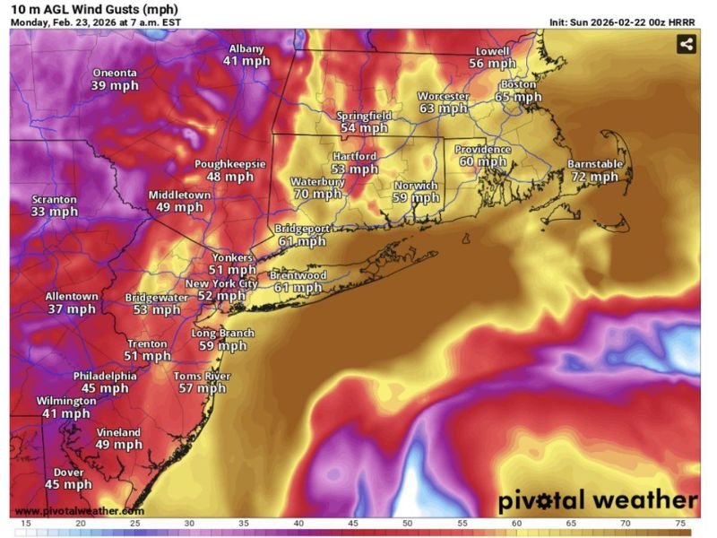
Wind Gusts Could Peak Monday Morning Across the I-95 Corridor and Coast
A wind gust projection for Monday, Feb. 23, 2026 around 7 a.m. EST shows a broad swath of strong winds from the Mid-Atlantic into New England. Gusts in the 50–70+ mph range appear possible near several major population centers, including New York City (around 52 mph), Bridgeport (about 61 mph), Brentwood on Long Island (about 61 mph), and Providence (around 60 mph).
Some of the highest values on the map are concentrated in southern New England, including Waterbury near 70 mph, Boston around 65 mph, and Barnstable near 72 mph, underscoring why outage and damage concerns are rising in Massachusetts and along the coast.
Why Wet Snow Makes Tree and Power Damage More Likely
Wet snow is dense and clings to branches and power lines, adding substantial weight even before the strongest winds arrive. When high wind gusts hit while that load is already in place, limbs can snap easily and whole trees can topple—especially if soils are soft or roots are weakened.
Forecasters say this “heavy snow plus high wind” overlap is the kind of setup that can create widespread outages rather than isolated neighborhood issues.
Power Outage Risk Rising in NJ, Long Island, CT, RI, and MA
The greatest outage concern is focused across New Jersey, Long Island, Connecticut, Rhode Island, and Massachusetts, where the heaviest snow and strongest winds may coincide. As the storm rapidly intensifies offshore, a tightening pressure gradient can further accelerate winds and increase the likelihood of structural damage, downed trees, and blocked roads.
What To Do Now Before Lights Start Flickering
Residents are urged to fully charge devices, secure loose outdoor items, and make sure emergency supplies are ready. If you plan to use a generator, ensure it is properly ventilated and positioned well away from your home to prevent deadly carbon monoxide buildup.
Are people where you live taking this storm seriously—stocking up, canceling travel, or preparing for outages? Share what you’re seeing and help others get ready by joining the conversation at SaludaStandard-Sentinel.com.