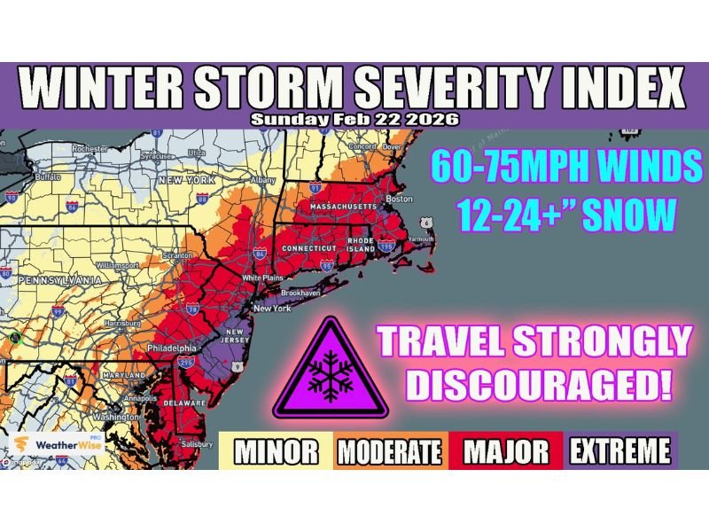
Massachusetts, New York and New Jersey Brace for ‘Extreme’ Winter Storm With 75-MPH Winds and 12–24+ Inches of Snow
UNITED STATES — A powerful winter storm is set to slam parts of the Mid-Atlantic and Northeast on Sunday, with forecasters placing several major cities under the “EXTREME” category of the Winter Storm Severity Index. The most dangerous conditions are expected overnight Sunday into Monday morning, with damaging winds and heavy snowfall creating life-threatening travel conditions.
The storm briefing highlights Boston, New York City, and Philadelphia among the metro areas facing the highest level of impact, as snow and wind combine to create blizzard-like conditions.
Winter Storm Severity Index Puts Major Cities in Extreme Zone
The Winter Storm Severity Index for Sunday, Feb. 22, 2026 shows a wide corridor of MAJOR to EXTREME impacts stretching from the Mid-Atlantic through southern New England. The deepest red and purple shading covers portions of Massachusetts, Connecticut, Rhode Island, New York, New Jersey, Delaware, and eastern Pennsylvania.
This classification signals not just heavy snowfall, but the likelihood of significant disruptions to daily life, including road closures, delayed emergency response, and possible power outages.
60–75 MPH Winds and 12–24+ Inches of Snow Expected
Forecast guidance indicates 60 to 75 mph wind gusts in the hardest-hit coastal and urban areas. When combined with 12 to 24 or more inches of snowfall, these winds can produce whiteout conditions, rapid snow drifts, and dangerous travel even on treated highways.
Strong gusts may also bring down tree limbs and power lines, especially where snow is wetter and heavier. Residents in exposed or coastal areas could see the most intense wind impacts overnight.
Worst Conditions Forecast Overnight Sunday Into Monday
Officials stress that final preparations should be completed by Sunday morning, with residents urged to be indoors by late afternoon as conditions begin deteriorating.
The most hazardous window is expected overnight Sunday into early Monday morning, when snowfall rates peak and winds are strongest. Travel during this time is strongly discouraged, as visibility may drop suddenly and roads could become impassable.
Residents Urged to Finish Preparations Early
Those in the storm’s path are encouraged to charge electronic devices, stock essential supplies, and check on vulnerable neighbors before conditions worsen. Even areas on the edge of the extreme zone could still experience significant travel disruptions and localized outages.
If you are in Massachusetts, New York, New Jersey, Pennsylvania, or surrounding states, how are you preparing for the storm? Share your local updates and safety tips with us at SaludaStandard-Sentinel.com.