New York, Massachusetts and Connecticut Could See 12+ Inches as Coastal New England Blizzard Risk Grows
NEW YORK, MASSACHUSETTS & CONNECTICUT — A high-impact winter storm setup is taking shape for the Northeast, and while snow totals are still uncertain, the latest guidance shows a dangerous corridor where Long Island through coastal New England could push past a foot of snow if the storm locks into the stronger track.
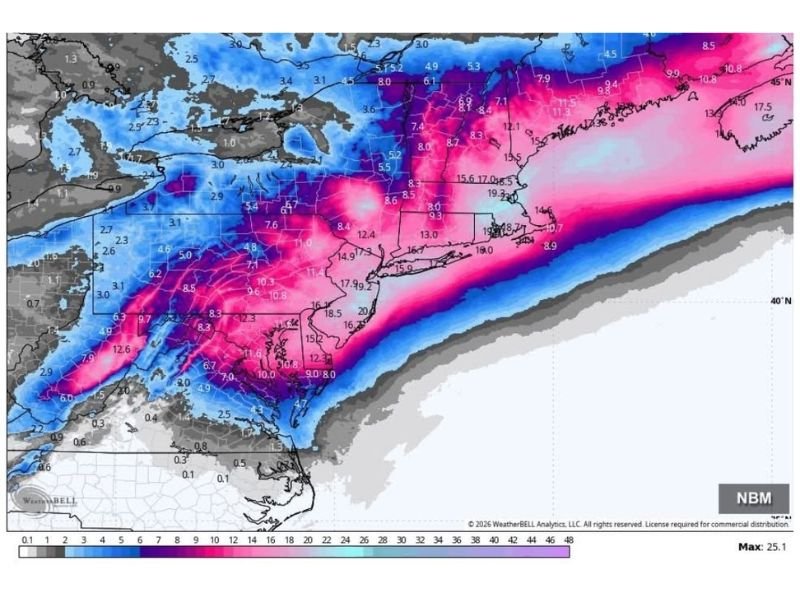
The projection shown in the latest snowfall map paints a wide swath of heavy accumulation stretching from the Mid-Atlantic into southern New England. The most aggressive snow band focuses on parts of New Jersey, New York, Connecticut, Rhode Island, and Massachusetts, with additional significant snow extending into New Hampshire and Maine. Forecasters note there are still “big question marks” on totals, but one key point is getting clearer: the potential for a major, disruptive storm is real.
What the Snow Map Suggests Right Now
The heaviest stripe (depicted in the deepest pink/purple shading) signals the zone where totals could reach 12 inches or more, and in some pockets potentially higher if the storm intensifies and slows. That band lines up closely with:
- Long Island and the New York City region
- Southern Connecticut
- Rhode Island
- Eastern and central Massachusetts, including the Boston area
Just north and west of that corridor, snow totals may drop off more quickly, showing how sensitive this forecast is to the storm’s exact track and where the sharp rain/snow line sets up.
Blizzard Conditions Possible Along Coastal New England
One of the most concerning signals in the update is the mention that blizzard conditions may be possible in coastal New England. That typically becomes a threat when heavy snow combines with strong winds, producing near-whiteout visibility and drifting snow. Even if final totals shift up or down, high winds can turn “just snow” into a travel and power-impact event.
Why Forecast Confidence Is Still Shaky
The update emphasizes that models are still wrestling with exact totals, but the stronger solution is “leading the way” in this latest snapshot. That means residents and travelers across the Northeast should treat this as a serious developing threat, not a routine snowfall forecast.
If you’re in New York, Connecticut, Rhode Island, Massachusetts, New Hampshire, or Maine, now is the time to watch forecast updates closely and avoid locking in travel plans until the track becomes clearer.
Want more multi-state storm tracking and impact-focused updates like this? Share what you’re seeing where you live and follow ongoing coverage at SaludaStandard-Sentinel.com.