Thunderstorms Sweep Into Michigan’s Lower Peninsula as Wind Advisory Warns of 45+ MPH Gusts Across Southern Michigan
MICHIGAN — Rain and thunderstorms are pushing into the Lower Peninsula early this morning, bringing lightning, the potential for isolated hail, and the threat of powerful non-thunderstorm wind gusts across southern Michigan.
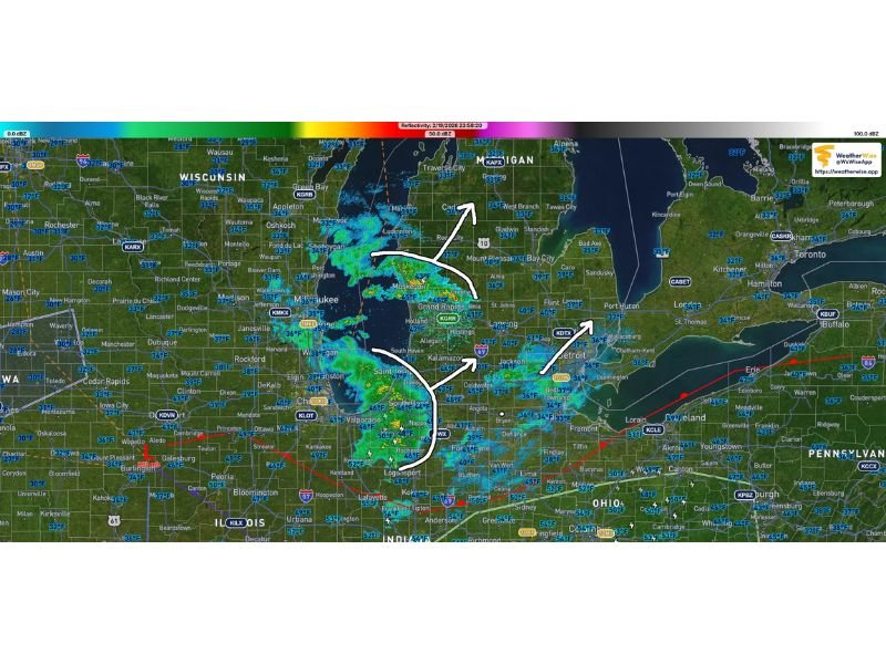
As of 12:03 a.m. EST on February 20, radar imagery showed a widening band of rain and embedded thunderstorms filling in across western and central portions of the state. Multiple reports of thunder and lightning were already coming in from the Grand Rapids area before midnight.
Forecasters say the overall coverage of storms is expected to expand slightly overnight — though the system is not forecast to intensify significantly in strength.
Thunderstorms Expanding Across the Lower Peninsula
The leading edge of storms moved through western Michigan and continued eastward into central portions of the Lower Peninsula.
While the storms are not expected to become widespread severe events, stronger updrafts within the line could produce:
- Isolated hail
- Frequent lightning
- Brief heavy downpours
Residents may notice scattered Special Weather Statements issued through the morning hours as storms pass through.
Wind Advisory in Effect for Southern Michigan
Beyond the thunderstorms, a separate and potentially more widespread concern is strong wind.
A Wind Advisory is in effect for all of southern Michigan through Friday, with gusts expected to exceed 45 mph.
Importantly, these gusty winds are not necessarily tied directly to the thunderstorms. Instead, they are associated with a broader pressure gradient tightening across the region.
By daybreak, winds are expected to strengthen significantly, leading to:
- Difficult travel, especially for high-profile vehicles
- Downed tree limbs
- Possible isolated power outages
- Blowing debris
Even after the thunderstorms move through, gusty conditions are expected to persist.
Hail Possible Overnight
Though the storms are not expected to dramatically increase in intensity, forecasters note that a few hail reports are possible overnight where stronger cells briefly develop.
These pockets of stronger convection could produce small hail and locally heavier rain, especially in western and central Michigan.
What Residents Should Expect
The overnight period will feature a steady push of rain and thunderstorms across much of southern and central Michigan. Lightning and brief bursts of heavier precipitation may reduce visibility for drivers during the early morning commute. As storms gradually move east, attention will shift to the strengthening winds through the day Friday.
Officials advise residents to:
- Secure loose outdoor items
- Use caution while driving, especially on highways
- Stay weather-aware for any updated advisories
While this is not expected to be a major severe outbreak, the combination of thunderstorms and strong gradient winds will make for an active and potentially disruptive weather day across southern Michigan. Stay with SaludaStandard-Sentinel.com for further updates as conditions evolve.