Texas, Arkansas, Tennessee and North Carolina in Potential Early-March Snow Corridor as European Model Paints Winter Comeback Across the South
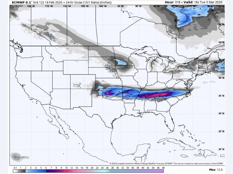
UNITED STATES — A long-range European weather model is hinting at a surprising early-March winter comeback, painting a potential snow corridor stretching from Texas through Arkansas, Tennessee and into North Carolina.
The projection, valid around March 3, shows a defined band of accumulating snow across parts of the southern Plains and lower Mid-South — areas that are typically shifting toward spring by that time of year.
European Model Signals Southern Snow Band
The ECMWF (European) model’s 24-hour snowfall projection displays a swath of snow extending from northern Texas into Arkansas, across western and central Tennessee, and east toward North Carolina .
Some of the heaviest modeled totals appear centered across portions of Arkansas and Tennessee, where deeper blues and purples suggest the potential for several inches if the setup verifies. While this remains several days out and subject to change, the model depiction is strong enough to raise eyebrows among meteorologists.
Not a Gulf Coast Snow — Focus Farther North
The modeled snow band does not appear centered along the immediate Gulf Coast. Instead, the highest probabilities are north of the coastline, impacting interior sections of Texas, Arkansas, Mississippi’s northern tier, Alabama’s northern counties, and Tennessee.
Farther east, portions of western and central North Carolina could also be within the snow zone if the storm track holds. Meanwhile, southernmost Gulf Coast communities may see little to no wintry impact based on this specific model run.
Early March Setup Adds Uncertainty
Early March snow events in the South are not unheard of, but they typically require precise alignment of cold air and moisture.
At this range, small shifts in the storm track could dramatically change where rain transitions to snow — or whether snow occurs at all. Warmer air pushing northward could suppress totals, while a stronger cold push could expand the snow corridor. Forecasters caution that this is a single model depiction and not a finalized forecast. Additional runs and agreement from other models will be needed before confidence increases.
What Happens Next
Over the coming days, meteorologists will watch trends in temperature profiles, moisture return from the Gulf, and the overall storm path. If the European model’s scenario begins gaining support, winter weather headlines could return for parts of Texas, Arkansas, Tennessee and North Carolina during the first week of March.
For now, it remains a potential setup — not a guarantee — but one that could briefly remind the South that winter is not quite finished.
If you live in Texas, Arkansas, Tennessee or North Carolina and are watching this potential early-March snow threat, share your thoughts with us at SaludaStandard-Sentinel.com. We’ll continue monitoring model trends and provide updates as confidence increases.