Scattered Showers Return to North Carolina and South Carolina Thursday as Mild 60s and 70s Hold Across the Region
SOUTH CAROLINA — More clouds and scattered showers are expected to move across the Carolinas on Thursday, though temperatures will remain mild across much of the region.
Forecasters describe the setup as “hit or miss,” meaning some neighborhoods may see brief showers while others stay mostly dry throughout the day.
Spotty Showers Across North and South Carolina
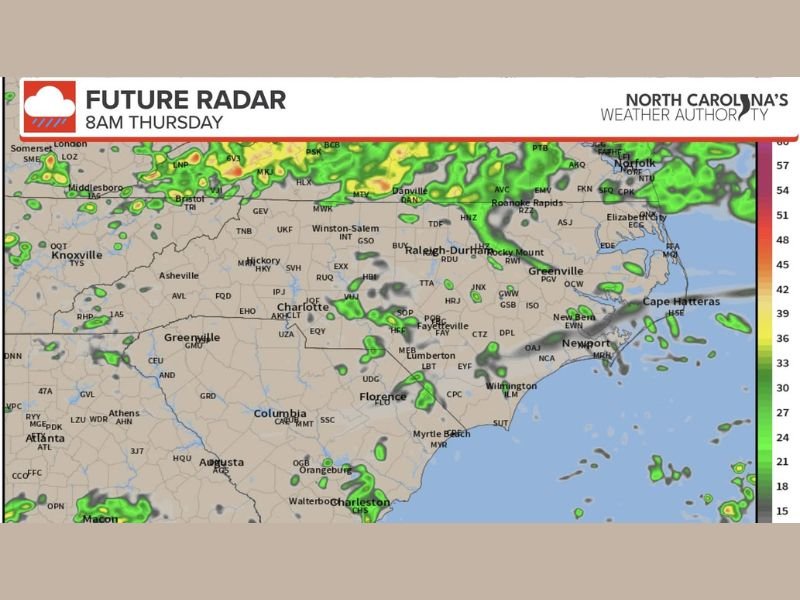
Future radar guidance for Thursday morning shows scattered rain developing across portions of North Carolina, especially north of Raleigh-Durham and toward the Virginia border.
By mid-morning, isolated showers appear across central North Carolina and parts of eastern South Carolina, including areas near Florence and Wilmington. Coastal communities from Myrtle Beach to Charleston could also see brief passing showers. The latest radar projection highlights these scattered pockets of precipitation across the region .
Very Hit-or-Miss Rainfall Pattern
Meteorologists emphasize that rainfall will not be widespread. Instead, showers are expected to be scattered and isolated, meaning coverage will vary significantly from town to town.
Some areas may experience short bursts of light rain, while others could remain dry with just increased cloud cover. The pattern appears especially scattered across the Midlands and Pee Dee regions. Drivers should be prepared for occasional slick roads where showers develop, but no significant flooding concerns are expected at this time.
Mild Temperatures Continue
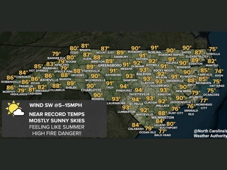
Despite the increase in cloud cover, temperatures will stay relatively warm for February. Northern areas across North Carolina are forecast to reach the 50s to low 60s, while much of South Carolina is expected to climb into the 60s and even 70s in southern counties. This combination of clouds and mild air will create a spring-like feel in many communities, even with occasional showers passing through.
What to Expect Through the Day
Showers are expected to move in and out throughout Thursday, with no single timeframe expected to bring steady rain across the entire region. Residents planning outdoor activities may want to keep an umbrella nearby, but most events should not see prolonged interruptions.
Forecasters will continue monitoring radar trends and updating the outlook as needed if coverage becomes more widespread than currently projected. If you experience showers in your area or notice changing weather conditions, share your updates with us at SaludaStandard-Sentinel.com. Community reports help keep everyone informed about what’s happening locally.