Tornado Threat Trending Up Across Illinois, Indiana, Ohio, Kentucky and Tennessee as Models Signal Elevated Risk Thursday Afternoon
ILLINOIS — The tornado threat is trending upward on several forecast models for Thursday’s severe weather event across the Ohio Valley, with elevated concern stretching from Illinois and Indiana into Ohio, Kentucky and Tennessee.
Forecasters say the greatest concern will be during the afternoon and early evening hours, when instability and moisture are expected to increase across the region.
Elevated Tornado Risk Developing Across the Ohio Valley
New model guidance indicates a growing signal for rotating storms, particularly from southern Illinois through central and southern Indiana, and eastward into Kentucky and Tennessee.
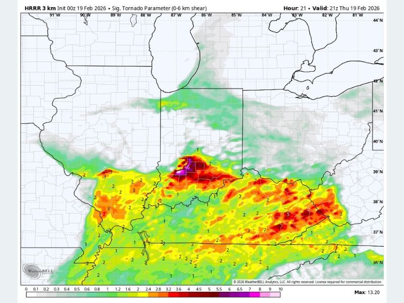
The latest significant tornado parameter map shows concentrated areas of higher values across portions of Indiana, Kentucky and Tennessee, suggesting an environment supportive of supercell development .
While this does not guarantee tornadoes, it signals that atmospheric ingredients — including wind shear and instability — may overlap during peak heating hours.
Illinois and Indiana in the Afternoon Focus
Storms are expected to develop during the afternoon across Illinois before shifting east into Indiana. This is when tornado potential could begin increasing.
Forecasters caution that moisture return will be a key factor. If instability builds as projected, isolated tornadoes could develop within stronger thunderstorms.
Areas along and south of Interstate 70 appear particularly vulnerable during this timeframe, with the risk gradually shifting eastward toward Ohio and Kentucky later in the evening.
Kentucky and Tennessee Also Within Risk Zone
Farther south, parts of Kentucky and Tennessee show notable signals for rotating storms by late afternoon into the evening.
The model output highlights pockets of enhanced tornado parameters across western and central Kentucky and into northern Tennessee. These areas could see discrete supercells capable of producing damaging winds, large hail and a few tornadoes.
However, meteorologists stress that not all storms will become tornadic. Some limiting factors remain in the setup, including the possibility that storms may outrun the richest moisture needed to sustain stronger updrafts.
Preparedness Key as Threat Evolves
Even though uncertainty remains, the upward trend in model guidance suggests residents across Illinois, Indiana, Ohio, Kentucky and Tennessee should remain alert. Forecasters recommend having multiple ways to receive weather warnings, especially during the late afternoon and evening hours when people may be traveling or away from home.
Weather conditions can change quickly in severe setups involving supercells. Any watches or warnings issued by the National Weather Service should be taken seriously. We will continue monitoring updated model runs and official outlooks as the event approaches.
If you live in the Ohio Valley and are preparing for Thursday’s severe weather, share your plans or concerns with us at SaludaStandard-Sentinel.com. Community awareness helps keep everyone informed and ready during evolving weather threats.