Level 2 Severe Risk Issued for Illinois and Indiana as Corridor of Greatest Tornado Threat Targets I-70 Region Thursday Afternoon
ILLINOIS — A Level 2 severe weather risk has been highlighted for portions of east-central Illinois into Indiana on Thursday, with forecasters identifying a corridor of greatest tornado threat from early afternoon into the evening hours.
The window of concern is expected to stretch from approximately 1 p.m. through 9 p.m., as supercell thunderstorms develop in an environment supportive of damaging winds, large hail, and a few possible tornadoes.
Corridor of Greatest Tornado Risk Identified Along I-70
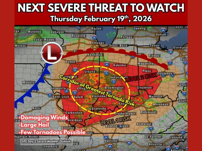
Forecast guidance shows the highest tornado potential centered along and just south of the Interstate 70 corridor, extending from central Illinois through Indianapolis and into western Ohio.
Cities including Springfield, Urbana, Bloomington, Vincennes, Evansville, Indianapolis, and Columbus fall within or near the highlighted risk zone. The area has been marked as the corridor of greatest tornado risk, where supercells could become more organized if atmospheric conditions align. The map outlining the Level 2 risk and the tornado corridor is shown in the latest severe weather outlook graphic .
Supercells Expected With Strong Wind Shear Aloft
Meteorologists note that storm mode is likely to be discrete supercells, especially during the mid-to-late afternoon hours. Strong wind shear aloft will provide rotation potential, increasing the risk for tornado development.
However, forecasters also caution that there are limiting factors within this setup. Storms may outrun the richest moisture supply, which could weaken updrafts and reduce the overall tornado threat. Even so, current projections indicate that most ingredients needed for tornado formation appear to be in place.
Damaging Winds and Large Hail Also Possible
In addition to tornado potential, the severe weather outlook highlights the risk of damaging straight-line winds and large hail across much of Illinois and Indiana within the Level 2 zone.
Farther south, a Level 1 risk extends into parts of southern Indiana and Kentucky, where storms could still produce isolated severe impacts. The greatest concern remains in the red-shaded Level 2 area, where storms may intensify quickly during peak heating hours.
Timing and Preparedness for Thursday
Storm development is expected to begin in Illinois during the early afternoon before expanding eastward into Indiana through the evening. Residents in the highlighted corridor are encouraged to stay alert throughout the afternoon and evening hours, especially between 1 p.m. and 9 p.m., when severe storms are most likely.
Officials recommend reviewing tornado safety plans, ensuring weather alerts are enabled on mobile devices, and identifying safe shelter locations in advance. Forecasts may be refined as additional data becomes available, and any watches or warnings will be issued by local National Weather Service offices.
If you are in Illinois, Indiana, or neighboring states and preparing for Thursday’s severe weather, share your storm plans or safety tips with us at SaludaStandard-Sentinel.com. Staying informed helps communities stay safer during rapidly changing weather conditions.