Indiana Storm Pattern Shifts This Week as Wednesday Brings Widespread Thunderstorms and Thursday Carries a Higher Severe Risk With Wind, Hail, and Isolated Tornado Potential
INDIANA — Forecast trends are pointing to a busy midweek stretch, with thunderstorms expected Wednesday and a more concerning severe-weather setup possible Thursday afternoon and evening, including the risk for damaging winds, hail, and isolated tornadoes.
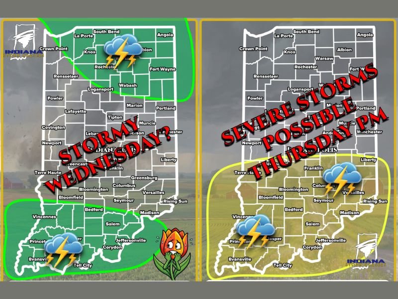
Wednesday: Thunderstorms Spread In, With Heavy Rain and Isolated Strong Wind Threat
The first round arrives Wednesday (02/18/26), with storms expected during the morning into early afternoon. The Wednesday setup is being described as generally weaker overall, but still capable of producing heavy rain, isolated flooding, and isolated damaging winds if storms briefly intensify.
The areas highlighted for Wednesday include northern Indiana and southern Indiana, with the message emphasizing that the atmosphere could “recharge” later in the day after early showers move out — though confidence is lower on whether storms become surface-based enough to turn truly severe.
Why Wednesday’s Severe Potential Is Still Uncertain
Even with wind shear working in the background, the limiting factor described is lack of strong lift near the surface. That matters because storms can look active aloft but struggle to fully organize at ground level. If that missing ingredient shows up at the right time, storms can upgrade quickly — but if it doesn’t, the result is more widespread rain and thunder with only isolated stronger pockets.
Forecasters are watching where the atmosphere can recover the fastest, with northern and far southern Indiana flagged as the most favored zones if anything “spicy” tries to develop.
Thursday: A Stronger Setup With a 15% Severe Signal Over Southern Indiana
Thursday (02/19/26) is the bigger day to watch. Guidance shown suggests a 15% chance of severe weather developing during the afternoon and evening, with southern Indiana highlighted as the main target area.
The hazards listed for Thursday include damaging winds, hail, and isolated tornadoes, with storm development expected as another cold front moves in and the atmosphere becomes more unstable compared to Wednesday.
Where the Highest Thursday Risk Could Focus
The highlighted southern Indiana zone includes areas near and around Evansville, Tell City, Jasper, and eastward toward Versailles and surrounding counties. While exact storm tracks will depend on where storms form and how quickly they organize, the signal is strong enough that residents in the southern half of the state should treat Thursday as a day to stay alert — especially late afternoon into the night.
What People Should Do Now Before the Next Update
Because midweek setups can shift fast, the most important step is making sure you can receive warnings quickly. Charge phones, enable emergency alerts, and plan where you would go if a warning is issued—especially if storms arrive after dark when people are more likely to be asleep.
If you’re in Indiana, tell us what conditions look like in your area as storms approach — and whether you’re in the northern or southern zone — by joining the conversation at SaludaStandard-Sentinel.com.