Michigan Dense Fog Advisory for February 14, 2026: Patchy Freezing Fog Could Drop Visibility Below Half-Mile Across Both Peninsulas
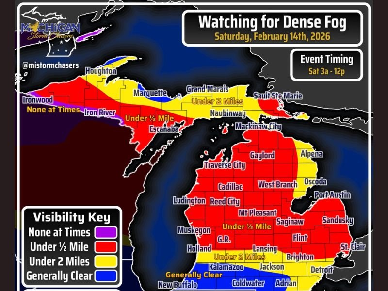
MICHIGAN — Forecasters are tracking another round of dense, patchy fog developing across both the Upper and Lower Peninsulas early Saturday morning, February 14, 2026, with some areas potentially seeing visibility fall below half a mile and pockets of freezing fog before conditions improve by midday.
The concern centers on the early morning hours between 3 a.m. and noon, when fog coverage is expected to fluctuate and shift unexpectedly across much of the state.
Patchy But Widespread Visibility Concerns
Meteorologists describe this setup as a “patchy” fog event — meaning not every location will experience the thickest conditions at the same time. However, the most likely outcome includes large portions of Michigan dropping into the “under ½ mile” visibility category, especially across central and northern sections.
Highlighted areas include:
- Grand Rapids and central Lower Michigan
- Traverse City and Cadillac
- Saginaw and Flint
- Portions of the Upper Peninsula including Escanaba
Some zones, particularly southern border counties, may remain generally clearer at times, but fog can shift quickly — meaning even clearer areas could briefly see reduced visibility.
Freezing Fog Possible in Colder Spots
With temperatures expected to fall below freezing in some locations Saturday morning, parts of the fog may become freezing fog, creating slick surfaces on elevated or untreated areas.
Freezing fog can leave a thin glaze on:
- Bridges
- Overpasses
- Sidewalks
- Vehicles
Officials say no widespread travel shutdowns are anticipated, but drivers should expect slower travel speeds where visibility drops sharply.
Visibility Could Improve by Late Morning
Forecast guidance suggests fog will gradually taper off toward the late morning to noon timeframe, allowing visibility to improve as temperatures rise and mixing increases.
Still, early commuters should plan for:
- Sudden visibility changes
- Low-beam headlights required
- Extra stopping distance
- Caution on untreated surfaces
No Major Travel Disruptions Expected — Just Slowdowns
At this time, no major closures or widespread hazardous travel events are projected. The primary issue will be reduced visibility and isolated slick spots where freezing fog forms.
Residents are encouraged to monitor local updates before heading out Saturday morning and allow extra time if traveling. Stay with SaludaStandard-Sentinel.com for continuing coverage of developing weather conditions across Michigan and beyond.