Pacific Northwest Winter Pattern Shifts as La Niña Fades, Bringing Rain, Mountain Snow, and Possible Lowland Flurries to Seattle
SEATTLE, WASHINGTON — A noticeable shift in the Pacific Northwest weather pattern is finally bringing more seasonable winter conditions, with cooler air, steady rain, and mountain snow expected in the coming days.
After a winter marked by inconsistent swings between warm and wet or cool and dry, meteorologists say the region is beginning to show signs of a more traditional late-season setup, even as La Niña conditions fade.
A Delayed Winter Feel Returns to the Pacific Northwest
For much of the season, mountain snowpack levels have lagged behind what is typically seen during stronger La Niña winters. Instead of steady snowfall, many higher elevations experienced fluctuating temperatures and weaker storm systems.
Now, cooler air flowing south from the Gulf of Alaska is beginning to take control. Unlike recent atmospheric river systems that tapped warmer, tropical moisture, this northwest flow carries colder air — a key factor in lowering snow levels across Washington and Oregon.
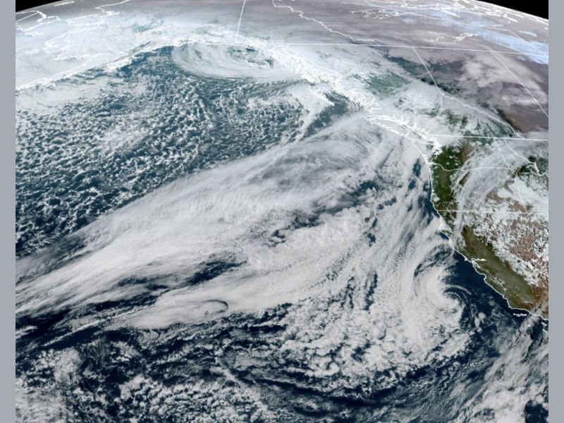
Satellite imagery shows a broad cloud shield and an active Pacific storm track aimed at the region, signaling a more classic winter pattern settling in.
Friday System to Bring Rain in Seattle, Snow in the Cascades
The first noticeable system is expected to move through western Washington on Friday. Light rain is likely from mid-to-late morning through the afternoon across Seattle and the greater Puget Sound area.
In the Cascades and other higher elevations, snowfall totals of 3 to 6 inches are possible. Winds may turn breezy at times, but forecasters do not expect a high-impact event for lowland communities.
Showers could linger into Friday night and early Saturday before gradual drying by Saturday afternoon. Sunday currently looks calmer and drier for Seattle, while the storm track shifts south toward California with rain for the Bay Area and Southern California and additional mountain snow there.
Cooler Pattern Next Week Could Trigger Lowland Snow Chances
By Monday, the broader shift in the weather pattern becomes more noticeable. Systems emerging from the Gulf of Alaska are expected to keep temperatures closer to seasonal averages and occasionally dip snow levels lower.
Forecast models have not yet reached full agreement on just how cold the air will be or how much moisture will be available. However, projections suggest a “fringey” setup — meaning small temperature changes could determine whether precipitation falls as rain or wet snow at lower elevations.
This does not point to a major Arctic outbreak or widespread snowstorm. Instead, it increases the possibility of brief, marginal lowland snow events where weather apps may occasionally hint at flurries in extended forecasts.
What This Means for Snowpack and the Rest of Winter
The developing pattern could provide a modest boost to mountain snowpack, which has been underwhelming for much of the season. Additional snow in the Cascades would be welcome for long-term water supply concerns heading into spring and summer.
For Seattle residents, winter may finally feel more authentic — even if it arrives later than usual. While significant snow accumulation in the city remains uncertain, the shift suggests colder, wetter conditions are here to stay for at least part of the upcoming week.
Have you seen changes in your local forecast or snow levels recently? Share your weather observations and experiences with us at SaludaStandard-Sentinel.com.