Pennsylvania and New Jersey on Alert as Potential Miller B Nor’easter Targets I-78/I-80 Corridor With Snow or Wintry Mix Sunday Into Monday
PENNSYLVANIA — Forecasters are closely monitoring the potential for a significant late-weekend snow event that could impact eastern Pennsylvania and parts of New Jersey, with precipitation possibly arriving Sunday afternoon or evening.
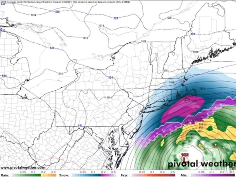
Meteorologist Mark Margavage says the developing system has characteristics of a Miller B Nor’easter, a storm type known for complex precipitation setups and sharp rain-snow dividing lines across the Mid-Atlantic and Northeast.
What Is a Miller B Storm?
Miller B systems typically begin as an inland low-pressure system that transfers energy to a new coastal low along the Atlantic. As the coastal low strengthens, colder air can wrap in from the north and west, allowing rain or a wintry mix to transition to heavier snow — especially north of the storm track.
In many past events, the critical mix line often sets up along the I-78 and I-80 corridors in eastern Pennsylvania and northern New Jersey, creating highly localized snowfall differences over short distances.
Model Guidance Remains Uncertain
Forecast models have shown significant variability over the past several days. While some guidance suggests a changeover to heavier snow as the storm intensifies, other runs keep warmer air entrenched or push the system farther south, limiting impacts.
According to the European model, precipitation could begin as a mix before transitioning to snow as strengthening occurs offshore. However, Margavage cautions that this outcome depends on “non-linear processes” aligning perfectly — meaning small changes in track or temperature profiles could dramatically alter snowfall totals.
At this point, no specific accumulation numbers are locked in, and forecasters stress that confidence in exact impacts remains low several days out.
Sunday Arrival Most Likely Timing
If the system does materialize as currently projected, precipitation would likely move into the region Sunday afternoon or evening and potentially continue into early Monday.
Key factors that will determine impacts include:
- Exact coastal low development timing
- Strength and positioning of high pressure to the north
- Availability of true cold air
- Storm track relative to the coastline
Should colder air fail to hold, parts of eastern Pennsylvania and New Jersey could see mostly rain or a rain-snow mix rather than significant accumulation.
Threat Remains, But Nothing Is Set
While some model trends have fluctuated, the overall message remains consistent: the storm threat is still on the table, but nothing is guaranteed. A shift south would largely spare the region, while a more amplified coastal development would increase snowfall potential along and north of I-78 and I-80.
Residents are encouraged to monitor updated forecasts through the remainder of the week as confidence improves. Winter storm watches, if needed, would likely be issued closer to the event once track certainty increases. For continued updates on this developing weekend system and regional weather impacts, visit SaludaStandard-Sentinel.com.