Oklahoma Braces for Widespread 1 to 3+ Inches of Rainfall This Weekend as Heavy Storm Bands Raise Isolated Flooding Concerns
OKLAHOMA — New forecast data released Friday afternoon shows Oklahoma is likely to receive widespread rainfall totals ranging from one to more than three inches through Sunday, with isolated flooding possible depending on where heavier storm bands develop.
Meteorologists indicate that rainfall will occur over a multi-day period from Friday through Sunday, allowing totals to gradually accumulate across much of the state.
Central Oklahoma Positioned for Heaviest Totals
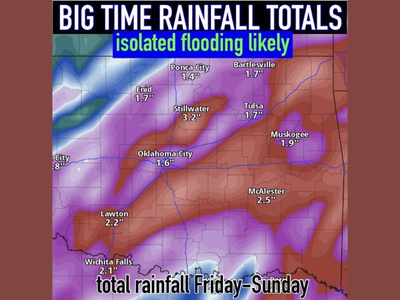
The highest projected rainfall amounts appear centered across portions of central Oklahoma. Stillwater is currently forecast to receive approximately 3.2 inches, one of the highest totals shown on the map.
Oklahoma City is projected near 1.6 inches, while surrounding areas could see locally higher totals depending on how storms organize. The placement of heavier rainfall bands will ultimately determine which communities receive the most significant accumulation.
Southern and Eastern Oklahoma Also Facing Significant Rain
Southern and southeastern portions of the state are also expected to receive substantial rainfall. Lawton is forecast near 2.2 inches, while McAlester could see around 2.5 inches.
In eastern Oklahoma, Tulsa and Bartlesville are each projected near 1.7 inches, with Muskogee closer to 1.9 inches. These totals suggest a widespread soaking event rather than isolated, brief showers.
Northern Areas Not Immune to Heavy Rain
Northern Oklahoma communities are also included in the heavier rainfall zone. Ponca City is forecast around 1.4 inches, and Enid could receive approximately 1.7 inches.
Forecasters caution that localized totals may exceed projections if storms repeatedly move over the same areas — a setup sometimes referred to as “training” storms.
Isolated Flooding Dependent on Storm Placement
While the forecast does not indicate widespread, major flooding at this time, isolated flooding remains possible, especially in low-lying or poor-drainage areas. The risk will largely depend on where the most intense downpours align during the Friday through Sunday timeframe.
Residents are encouraged to monitor updated forecasts as additional model runs refine rainfall placement and totals. Have you already noticed rainfall totals climbing in your area? Share your local conditions and stay informed with ongoing updates at SaludaStandard-Sentinel.com.