Pennsylvania Sees Late-Day Rain, Freezing Rain Risk, and Isolated Thunder as Temperatures Rise Into 30s, 40s, and Near 50 Tuesday
PENNSYLVANIA — Pennsylvania is seeing a shift in weather conditions Tuesday as temperatures climb into the 30s, 40s, and even near 50 degrees in parts of the state, bringing rain back to the forecast for the first time in several weeks.
Most of the day is expected to remain dry, but precipitation chances increase late in the afternoon and evening as a disturbance moves through the region.
Rain Returns for Much of the State Late Tuesday
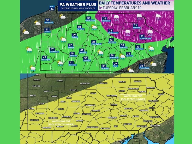
Forecast data shows plain rain becoming the primary precipitation type across much of central, southern, and western Pennsylvania, especially after 5 to 6 p.m. Areas in south-central and southwestern Pennsylvania may briefly reach the upper 40s to near 50 degrees during the afternoon.
Some rain showers could become steadier during the evening hours, and a few rumbles of thunder cannot be ruled out.
Freezing Rain and Sleet Possible in Northeastern Pennsylvania
Colder air lingering across northeastern Pennsylvania is expected to keep surface temperatures near or below freezing in some locations. This creates the risk for scattered freezing rain and sleet showers, particularly between 6 p.m. and 12 a.m. Tuesday night.
A light glaze of ice is possible on surfaces below 32 degrees, including roads, bridges, and overpasses. Travel conditions may become slick in isolated areas as temperatures fluctuate.
Isolated Thunder Linked to Elevated Instability
Forecast guidance indicates some elevated instability ahead of the disturbance, which may allow for isolated thunder within rain or mixed precipitation showers. Severe weather is not expected, but the presence of thunder is notable for this time of year and signals a gradual transition toward spring-like patterns.
Dry Start, Late-Day Caution Advised
Despite the unsettled evening forecast, most locations will experience a dry start to the day. Officials advise travelers to remain alert during the evening hours, particularly in areas prone to icing, as conditions may change quickly.
Residents are encouraged to monitor updates and share local conditions as the system moves through. Stay informed with continued coverage at SaludaStandard-Sentinel.com.