Michigan Braces for Dangerous Wind Chills as Temperatures Plunge to 0° to -15° Monday Morning Before Brief Warm-Up
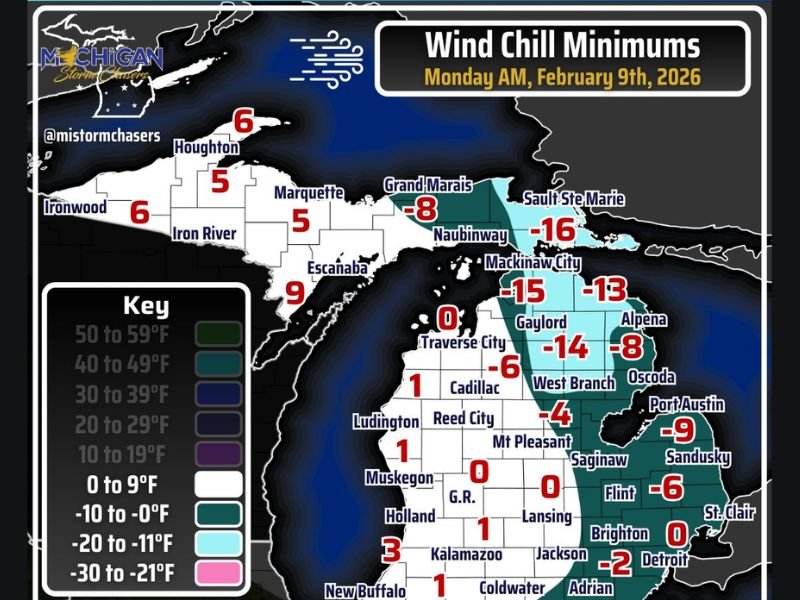
MICHIGAN — Winter is refusing to loosen its grip on the Great Lakes, as much of Michigan is expected to wake up to dangerously cold wind chills early Monday morning, with values ranging from 0°F to as low as -15°F across large portions of the state.
Forecast data shows the coldest conditions setting up during the early hours of Monday, before temperatures begin a gradual rebound heading into Tuesday.
Northern and Eastern Michigan See the Coldest Wind Chills
The harshest cold is expected across northern and eastern Michigan, where wind chill readings may drop to -16°F in areas such as Naubinway and Mackinaw City.
Communities including Gaylord, West Branch, Alpena, and Oscoda are forecast to experience wind chills between -8°F and -14°F, making Monday morning especially dangerous for anyone spending extended time outdoors.
Southeast Michigan Not Spared From the Deep Freeze
Even southeast Michigan will feel the impact of the cold surge. Cities such as Detroit, Brighton, Flint, and Adrian are expected to see wind chills hovering between -2°F and 0°F, enough to cause discomfort and potential frostbite with prolonged exposure.
While actual air temperatures may not reach those extremes, persistent winds will significantly amplify the cold, creating hazardous conditions statewide.
Wind Chill Dangers Increase During Morning Hours
Wind chills in the 0°F to -15°F range can cause frostbite on exposed skin in as little as 15 to 30 minutes. The cold will be most noticeable during early morning commutes, school travel, and outdoor work hours.
Residents are urged to dress in layers, cover exposed skin, and limit unnecessary time outdoors. Vehicles may also struggle in the cold, with higher risks for dead batteries and mechanical issues.
Relief Arrives Tuesday, But Winter Isn’t Done
There is some relief on the way. Forecast guidance indicates that Tuesday will feel noticeably milder, with temperatures rebounding into the upper 30s and even low 40s in parts of southern Michigan.
Forecasters caution, however, that snow and ice on the ground will be slow to melt, and the warm-up is expected to be temporary rather than a sign of spring.
What to Expect Moving Forward
While Tuesday’s warmth may feel dramatic after Monday’s deep freeze, winter remains firmly in control across Michigan. Additional cold snaps remain possible as February continues.
This latest surge serves as another reminder that Michigan winters can still deliver punishing cold, even when brief breaks appear in the forecast. For continued winter weather updates and impact coverage, stay with SaludaStandard-Sentinel.com.