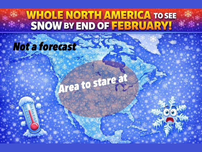
“Whole North America Will See Snow by End of February” Graphic Spreads Online — Here’s What It Really Means
UNITED STATES — A colorful graphic circulating online is grabbing attention with a bold headline suggesting “whole North America” could see snow by the end of February. The post behind it repeatedly stresses one key point: it is not presenting an official forecast, but rather a tongue-in-cheek way to highlight how chaotic longer-range weather patterns can look on computer models.
What the Viral “North America Snow” Post Is Claiming
The message frames the graphic as an “emotional preparation” map — essentially a joke aimed at weather-watchers who spend too much time staring at model data 8–10 days out. It suggests that when extended-range guidance gets noisy, it can temporarily look like snow “could happen anywhere,” even in places that rarely see it.
The post also jokes that if this scenario ever “verified,” people everywhere would be doing the same winter routines — stocking up on basics, checking the window repeatedly, and debating forecast accuracy in the comments.
Why This Isn’t a Real Forecast
Long-range model snapshots can swing dramatically from run to run, especially when the atmosphere is transitioning between warm and cold patterns. That’s why the post keeps repeating that it’s not calling for a continent-wide snow event.
In practical terms, a single viral graphic like this should be treated as weather chatter, not a hard prediction. Real forecasts narrow down as the event gets closer, and the details that matter most — timing, storm track, temperatures, and moisture — usually aren’t reliable at extreme lead times.
The Smart Takeaway for Readers Right Now
Even when a post is joking, it taps into something real: late February can still deliver quick shifts. If you live in a colder-prone region, it’s worth doing a simple winter check:
- Keep a basic emergency kit in the car (blanket, flashlight, charger).
- Make sure you know where gloves, coats, and ice melt are.
- If you travel for work, watch for updated local advisories instead of social media graphics.
What to Watch Next
If a legitimate winter threat develops later in the month, you’ll see it show up consistently across multiple forecast updates — not just one eye-catching map. Until then, treat the viral “North America snow” image for what it appears to be: a humorous reminder that weather models can look wild before they lock in.