Valentine’s Day Weather Models Raise Concern as Strong Low Pressure and Powerful Jet Stream Signal Potential Southeast Storm Setup
SOUTHEASTERN UNITED STATES — Weather models are beginning to raise early concerns for Valentine’s Day as a consistently modeled strong low-pressure system and unusually powerful upper-level winds take shape across the southeastern United States, according to long-range forecast data observed over the past several days.
While no official severe weather outbreak is being forecast at this time, meteorologists monitoring the situation say the pattern developing in the upper atmosphere is one that historically deserves close attention.
What the Models Are Showing Right Now
Forecast guidance from multiple major models has consistently indicated the presence of a strong low-pressure system coinciding with powerful upper-level jet stream winds over the Southeast around Valentine’s Day. This combination can act as a catalyst for organized storm development when other ingredients come together.
One key feature appearing repeatedly is a robust squall line signal, suggesting the potential for a long, organized line of thunderstorms rather than isolated activity. Squall lines are capable of producing widespread impacts, especially when supported by strong winds aloft.
Importantly, forecasters stress that this is not a formal severe storm forecast, but rather an early signal that the atmosphere may be trending toward a more active setup.
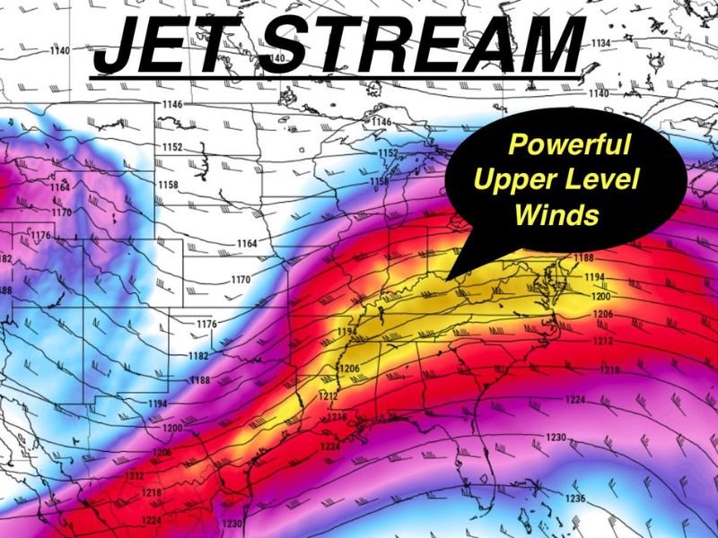
Why the Jet Stream Matters So Much
The jet stream shown in the imagery is notably strong, with intense upper-level winds sweeping across the southern and southeastern states. When winds at these levels become powerful, they can help storms organize, persist longer, and sometimes intensify.
Upper-level winds provide ventilation for storms, allowing rising air to escape more efficiently. When combined with a strong surface low, this can lead to widespread rain, gusty winds, and embedded thunderstorms if sufficient moisture and instability are present closer to the event.
Valentine’s Day Timing Raises Eyebrows, Not Alarms
The timing of the modeled pattern — landing near Valentine’s Day — is what has caught the attention of weather watchers. The consistency of the signal over several days is notable, even though it remains well outside the short-term forecast window.
Forecasters emphasize that many things can still change, including storm strength, exact placement, and whether severe weather even develops at all. Long-range models are best used to identify trends, not outcomes.
A “Watch the Pattern” Moment, Not a Prediction
Those analyzing the data have been clear: this is not a declaration of an upcoming severe weather outbreak. Instead, it is a request for awareness. When strong low pressure, powerful jet stream winds, and squall line signals repeatedly appear together, meteorologists take notice — even days in advance.
As the date approaches, higher-resolution data and official forecasts will provide clearer answers about potential impacts.
What Residents Should Do Now
At this stage, the best advice is simply to stay informed and follow updates as confidence increases or decreases. Early awareness allows residents to avoid being caught off guard if the forecast sharpens closer to Valentine’s Day.
For continued monitoring of developing weather patterns across the Southeast and the Carolinas, stay with SaludaStandard-Sentinel.com for updates as newer forecast data becomes available.