Extreme Cold and Winter Storm Warnings Grip Florida, Georgia, Alabama, Mississippi, and the Carolinas as Arctic Air Spreads Across the Southeast
SOUTHEASTERN UNITED STATES — A powerful surge of Arctic air is tightening its grip across the Southeast tonight and into tomorrow, bringing a combination of dangerous cold temperatures and winter storm conditions that are prompting widespread warnings from the Gulf Coast to the Carolinas. Forecasters say this is not just another chilly night — it’s a high-impact cold event with real safety concerns.
Extreme Cold and Winter Storm Warnings Explained
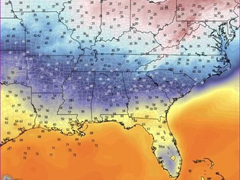
The latest advisory maps show a sharp divide across the region. Blue-shaded areas are under Extreme Cold Warnings, while pink-shaded zones are under Winter Storm Warnings, signaling two different but equally serious threats.
In areas under Extreme Cold Warnings, overnight temperatures are expected to plunge well below normal, with wind chills dropping into the single digits and teens. These conditions can cause frostbite on exposed skin in a short amount of time and place added strain on heating systems, pipes, and power infrastructure.
Meanwhile, regions under Winter Storm Warnings are bracing for snow, icy conditions, and hazardous travel, with cold air ensuring that whatever falls will stick quickly and linger.
Why This Cold Is Especially Concerning
Meteorologists point to a strong and well-organized polar vortex pattern that is allowing repeated shots of Arctic air to spill southward. Unlike brief cold snaps, this setup keeps temperatures suppressed overnight and limits daytime recovery.
Forecasters warn that Sunday morning appears to be the coldest window, with wind chills potentially reaching their lowest levels just before sunrise. Even areas accustomed to winter weather could feel the bite, while parts of the Deep South face conditions that are rare for late January.
Impacts Across the South and Southeast
The cold surge is affecting a wide swath of the region:
- Gulf Coast states, including parts of Florida, are seeing freeze and extreme cold alerts rarely issued this far south
- Georgia, Alabama, and Mississippi are dealing with prolonged freezing temperatures and dangerous wind chills
- The Carolinas and Tennessee Valley are facing a combination of snow potential and bitter cold
- Coastal areas may experience strong winds, increasing the risk of power disruptions and dangerous marine conditions
Even locations not expecting snowfall are urged not to underestimate the cold, as exposed pipes, pets, and vulnerable individuals are at risk.
Safety Precautions Residents Should Take
Emergency officials recommend several immediate steps:
- Bring pets indoors and check on elderly neighbors
- Protect exposed pipes by insulating or allowing faucets to drip
- Avoid unnecessary travel in winter storm warning areas
- Dress in layers and limit time outdoors, especially overnight and early morning
- Use space heaters safely and never leave them unattended
Officials also caution against relying on improvised heating methods, which can increase the risk of house fires or carbon monoxide exposure.
What Happens Next
While temperatures will eventually moderate, forecasters say the overall pattern remains active, meaning additional cold shots and winter weather chances could follow into early February. Residents are urged to stay weather-aware and monitor local updates as conditions evolve.
This is shaping up to be one of the more notable cold outbreaks of the season for the Southeast, combining uncomfortable temperatures with genuine safety hazards. What are conditions like where you live, and how are you preparing for the cold? Share your experience and stay connected with SaludaStandard-Sentinel.com for continued weather updates and local coverage.