South Carolina, North Carolina, and Mid-Atlantic States Brace for Rapidly Strengthening Nor’easter as Offshore Bomb Cyclone Develops
EAST COAST, UNITED STATES — A rapidly intensifying nor’easter is taking shape offshore of the Eastern Seaboard, strengthening at an accelerated pace as it moves north — a classic “bombing out” scenario that forecasters say could bring far more than just snowfall to large portions of the East Coast.
Meteorologists are warning that the storm’s evolution points to a high-impact event capable of delivering heavy snow, damaging winds, coastal impacts, and potential power disruptions, particularly from the Carolinas northward into the Mid-Atlantic.
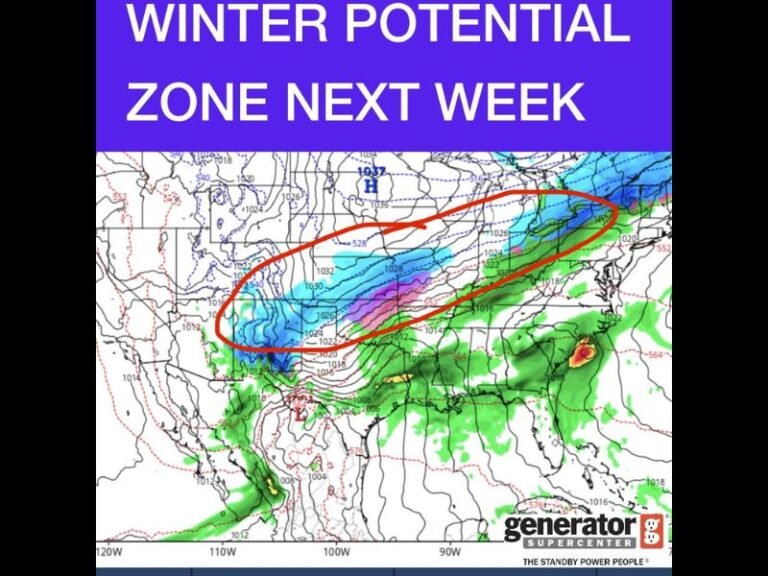
Why This Storm Is Intensifying So Quickly
What makes this system stand out is not just projected snowfall, but the speed and efficiency with which the atmosphere is responding. The storm is feeding on sharp temperature contrasts, an unusually energized jet stream, and a rapidly falling surface pressure — all aligning nearly simultaneously.
Instead of gradually strengthening, the system is accelerating into its mature phase, a signal that atmospheric conditions are snapping into place rather than easing in.
Snowfall Is Only Part of the Threat
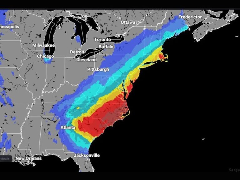
Heavy snow is expected to target the Carolinas and extend northward into parts of the Mid-Atlantic, but forecasters stress that snowfall totals alone do not capture the full risk profile of this storm.
As pressure continues to fall offshore, winds are forecast to intensify to potentially damaging levels, raising concerns for coastal flooding, power outages, and dangerous travel conditions. Coastal regions appear especially vulnerable as the tightening pressure gradient enhances wind speeds.
Atmospheric Setup Points to a High-Impact Event
Storms of this magnitude do not develop in isolation. This system is the result of several powerful atmospheric ingredients aligning at once:
- Cold air firmly locked in place inland
- Warm ocean energy fueling development offshore
- Strong upper-level winds acting as a trigger
When these layers stack correctly, the response is often sudden and forceful — a hallmark of rapidly intensifying nor’easters.
What Residents Along the East Coast Should Expect
With conditions expected to change rapidly, residents in the projected path of the storm are urged to take warnings seriously and prepare for quickly deteriorating weather, particularly near the coast.
Forecasters note that those who have been closely watching weather trends may already sense that this system feels different — another example of storms intensifying faster than past norms.
Stay with SaludaStandard-Sentinel.com for continued updates, refined forecasts, and localized impact details as this powerful East Coast storm continues to evolve.