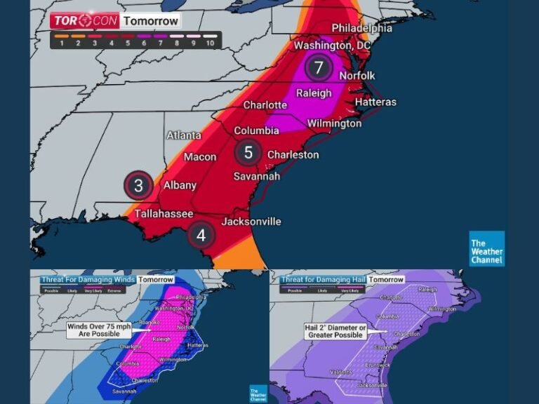
Uncertain but Potentially Powerful Coastal Winter Storm Could Bring Heavy Snow and Damaging Winds to New England Late This Weekend
NEW ENGLAND — Unlike last weekend’s winter storm, meteorologists say this upcoming system remains highly uncertain, but forecast models continue to signal the development of a strong coastal winter storm that could impact parts of New England from late Saturday night through Monday morning. While confidence is still limited, the range of possible outcomes includes heavy snow, strong winds, and dangerous coastal conditions, particularly if the storm tracks closer to shore.
What Meteorologists Know Right Now
Forecast guidance is aligned on several key aspects of the developing system:
- A strong coastal low-pressure system is expected to form offshore
- Snow and strong winds are possible, especially near the coast
- Powerful wind gusts could affect coastal communities
- The most likely impact window is late Saturday night through Monday morning
While these factors are consistent, the severity and inland reach of impacts remain uncertain.
What Forecasters Still Don’t Know
Several critical details will determine how serious this storm becomes:
- The exact track of the coastal low
- Snow accumulation totals, especially how far inland snow extends
- The maximum wind gust potential, particularly along exposed coastal areas
Even a small shift in the storm’s path could dramatically change local impacts.
European Model Shows Increasing Snow and Wind Risk
The European (EURO) model — often a reliable performer in New England winter storms — has shown a westward track trend over multiple runs. This scenario would bring the storm closer to the coast and farther inland.
If this solution verifies:
- Eastern Massachusetts, Rhode Island, Cape Cod, and the Islands could see heavy snowfall, potentially approaching two feet in some areas
- Moderate snow would extend into coastal Maine and toward the New Hampshire–Vermont border
- Storm-force wind gusts near 70 mph could impact Cape Cod and other exposed coastal locations, approaching Category 1 hurricane strength
GFS Model Favors a More Offshore Solution
The GFS model continues to depict a farther-offshore storm track, which would significantly reduce inland impacts.
Under this scenario:
- Snow would be mainly confined to Cape Cod and the Islands
- Metro Boston could see little more than a light dusting
- Coastal winds would still be strong, but inland gusts would likely remain in the 20–30 mph range
ICON and Canadian Models Limit Local Impacts
Both the ICON and Canadian models keep the storm largely offshore, with most significant impacts targeting eastern Canada and the Canadian Maritimes, leaving southern New England with minimal snowfall.
Why Confidence Remains Low
Unlike the previous storm, forecast models are not yet aligned, making it difficult to issue precise snowfall or wind forecasts. Short-range models such as the NAM have not fully captured the system yet, which is expected to happen as the storm approaches.
What Happens Next
Confidence is expected to improve over the next 24 to 48 hours as higher-resolution models come into focus. Residents across New England — especially in coastal and eastern areas — are urged to monitor updates closely as the forecast evolves.
For continued updates on this developing winter storm and other regional weather coverage, follow SaludaStandard-Sentinel.com.