Carolinas Face Growing Saturday Snow Threat as GFS Tracks Coastal Low Over Deep Cold Air With Potential for Higher Snow Ratios
CAROLINA REGION — A developing winter weather system is drawing increasing attention across the Carolinas as overnight forecast data suggests a strengthening low-pressure system could spread snow across the region Saturday, especially where very cold air is already firmly in place.
Meteorologists caution the forecast is still evolving, but trends now show a clearer signal for snow potential, with the greatest concern shifting toward eastern portions of North Carolina closer to the Atlantic moisture source.
Why Saturday’s Setup Is Gaining Attention
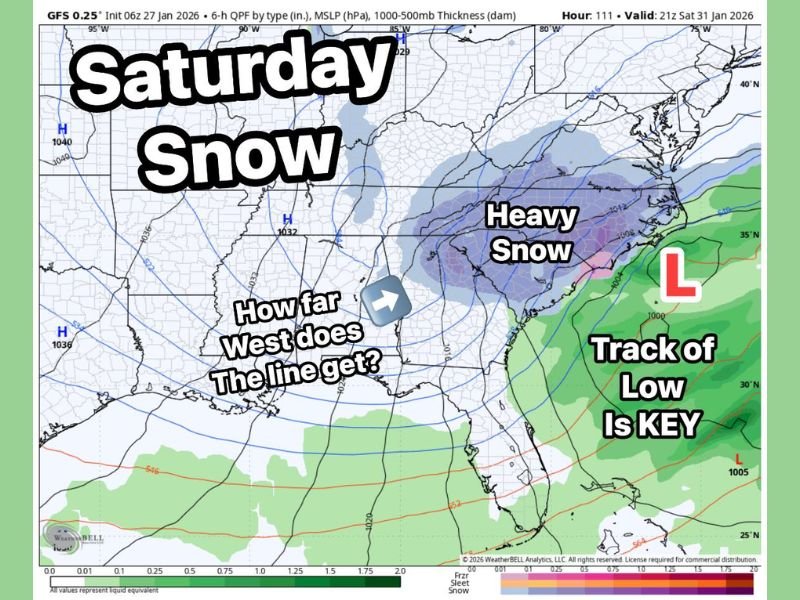
The overnight GFS model run places a developing low-pressure system in a favorable position to send moisture back over a deeply entrenched cold air mass. Temperatures across much of the Carolinas are expected to remain in the teens and low 20s during the event, a key factor that increases snow efficiency.
Forecasters note that when temperatures are this cold, the typical 10:1 snow-to-liquid ratio often underperforms. Instead, ratios closer to 15:1 or even 20:1 become possible, allowing lighter precipitation to produce higher snow totals.
Colder Air Could Mean Lighter, More Efficient Snow
With such cold surface and mid-level temperatures, any snow that develops would likely be dry and fluffy rather than wet and heavy. This raises the potential for quick accumulations even if overall precipitation amounts remain modest.
This efficiency is one reason meteorologists are closely watching the system despite lingering uncertainty in exact placement and intensity.
Eastern North Carolina Faces Higher Impact Risk
Forecast guidance suggests the farther east the system tracks, the greater the snowfall potential becomes, particularly across eastern North Carolina where proximity to Atlantic moisture increases precipitation coverage.
If the low remains close enough to the coast, snow bands could intensify inland, raising the risk of higher accumulations and travel impacts in those areas.
How Far West the Snow Reaches Remains Uncertain
For western areas of the Carolinas — and even locations as far west as parts of Georgia — the forecast hinges on how close the low-pressure center tracks and where the western edge of the snowfall sets up.
A small east or west shift could dramatically change who sees accumulating snow and who remains dry, making upcoming model runs critical for refining impact zones.
System Expected to Strengthen Into Major Northeast Storm
As the system moves beyond the Carolinas, it is expected to intensify into a major winter storm impacting the Northeast. While the Carolinas will be on the southern edge of the system, that same strengthening process could enhance snowfall potential locally if timing and placement align.
Forecasters emphasize that confidence will rise or fall quickly as new data arrives over the next couple of model cycles.
Residents across the Carolinas are encouraged to stay alert for forecast updates as the Saturday snow threat becomes clearer. Share your local conditions or preparations with SaludaStandard-Sentinel.com as meteorologists continue tracking this developing winter system.