Indiana Braces for Dangerous Blowing Snow and Ground Blizzard Conditions as Wind Gusts Reach 40 MPH Tuesday
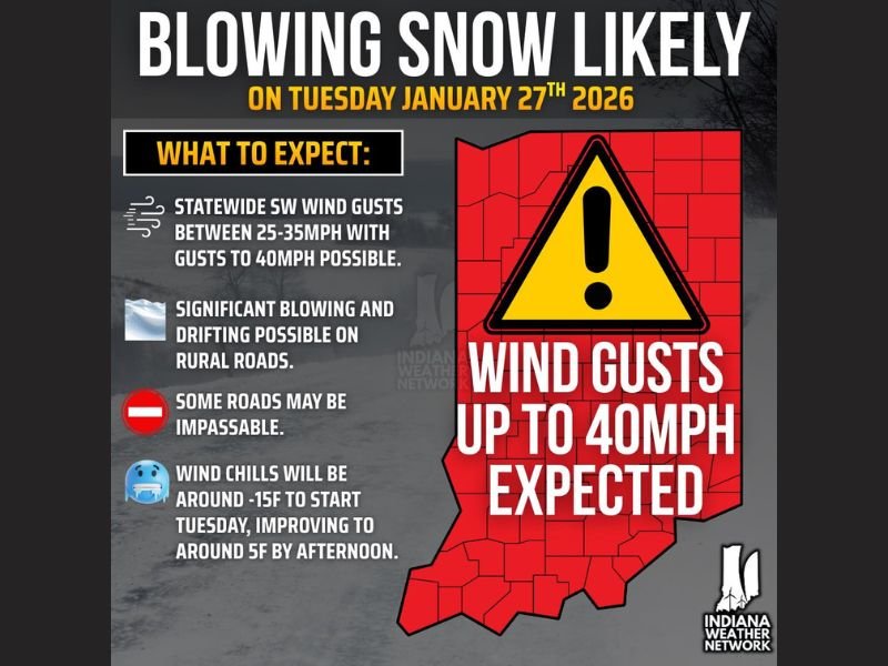
INDIANA — Attention is now turning to Tuesday morning, January 27, 2026, as a surge of strong winds is expected to create hazardous blowing and drifting snow conditions across much of Indiana. Forecast data shows statewide wind gusts between 25 and 35 mph, with northern Indiana facing the highest risk for gusts up to 40 mph or higher, raising serious travel and visibility concerns.
While snow will not be actively falling in many areas, the combination of light, fluffy snow already on the ground and strengthening winds could lead to dangerous ground blizzard conditions, particularly in open and rural areas.
Strong Winds Set to Intensify Overnight
Winds are expected to increase overnight Monday into early Tuesday, becoming strongest during the morning hours. These sustained gusts will be powerful enough to lift loose snow off the ground, creating sudden whiteout conditions even under clear skies.
Meteorologists warn that this type of scenario can be especially dangerous, as drivers may not expect rapidly changing visibility when snowfall has already ended.
Ground Blizzard Conditions a Major Concern
Ground blizzards occur when snow on the ground is violently blown by wind, rather than falling from the sky. Visibility can drop sharply to near zero, making travel extremely hazardous.
This risk will be highest across northern and rural portions of Indiana, where open fields allow snow to drift freely across roadways. Even short-distance travel could become difficult or impossible at times.
Rural Roads May Become Impassable
Officials warn that some rural country roads could be drifted shut, especially where snowbanks are already present. Blowing snow may also make it difficult for road crews to keep up with rapidly changing conditions.
Residents in affected areas are urged to limit unnecessary travel, particularly during the early morning and midday hours when winds will be strongest.
Bitter Wind Chills Add to the Danger
In addition to visibility issues, dangerously cold wind chills will add another layer of risk. Wind chill values are expected to be near -15°F early Tuesday morning, gradually improving to around 5°F by afternoon. Prolonged exposure to these conditions could lead to frostbite in a short amount of time, especially when combined with strong winds.
What Residents Should Do Now
Drivers are encouraged to check road conditions before traveling, keep emergency supplies in vehicles, and allow extra time if travel is unavoidable. Pedestrians should dress in layers and protect exposed skin. Conditions may improve later Tuesday, but officials stress that even brief periods of blowing snow can be life-threatening.
Have you experienced ground blizzard conditions before? Share your thoughts and stay informed with continued winter weather coverage at SaludaStandard-Sentinel.com.