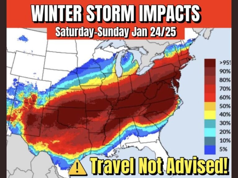
Major Winter Storm Signals Intensify as Models Shift North, Raising Heavy Snow and Ice Threat From the Plains to the Ohio Valley and Appalachians
UNITED STATES — Confidence is steadily increasing that a high-impact winter storm will affect a large portion of the country from Sunday into Monday, as overnight model runs reveal a notable northward shift in the storm track. While important details are still being refined, the evolving setup now favors wider heavy snow potential, with dangerous ice and sleet zones still very much in play across parts of the southern and central United States.
This is a classic winter pattern where small shifts north or south—sometimes just 50 to 100 miles—can dramatically change impacts, and forecasters are stressing patience as the final pieces fall into place over the next 24–48 hours.
A Key Shift in the Storm Track Is Raising Snow Potential
The most recent guidance shows the storm’s core energy tracking farther north than earlier projections, a development that significantly boosts the odds of heavy accumulating snow in areas that were previously on the edge of the system.
This shift is being driven by several reinforcing factors working together:
- Deep Gulf moisture surging northward
- Cold arctic air firmly locked in at the surface
- A strengthening low-pressure system riding northeast
- Improving agreement among major global models
As these elements phase more efficiently, snowfall coverage expands, and confidence grows that some locations could see major winter impacts rather than a near-miss.
Heavy Snow Corridor Becoming More Defined
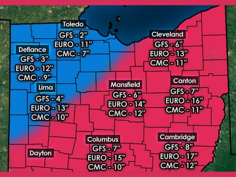
Model projections now indicate a broad swath of 6 to 12 inches of snow is increasingly possible within the favored snow band, with locally higher totals where mesoscale banding develops. Several high-confidence zones are beginning to emerge, especially where colder air remains deeply entrenched throughout the event.
While exact placement is still not locked in, red-shaded zones on the latest guidance represent areas with the strongest signal for 5 inches or more of snow, and blue zones show moderate confidence for similar totals. These zones may continue to shift as the storm approaches, but the overall signal for a significant snow producer is strengthening.
Ice and Sleet Remain a Serious Concern South of the Snow Line
Despite the improving snow signal farther north, ice is still the primary hazard across parts of the southern United States. In these areas, warm air aloft overriding subfreezing surface temperatures creates a setup favorable for freezing rain and sleet.
Forecasters are particularly concerned about:
- Freezing rain amounts exceeding 0.50 inches in some areas
- Long-duration icing lasting up to 48 hours
- Significant power outage potential
- Tree damage and impassable roads
Sleet-heavy corridors could also see inches of accumulation, which may not cause widespread power failures but can make travel nearly impossible due to dense, slow-melting ice pellets.
Why This Storm Is Especially Tricky to Forecast
Winter storms like this are notoriously difficult because precipitation type matters just as much as precipitation amount. A shallow change in temperature profiles can flip snow to sleet—or sleet to freezing rain—over a very short distance.
Additional uncertainty comes from:
- The exact position of the arctic high to the north
- How quickly cold air damming strengthens east of the Appalachians
- Whether dry air briefly limits snowfall at the onset
- How fast the low-pressure system intensifies
These factors are why forecasters caution against focusing too heavily on exact numbers until the system moves within the 48-hour window, when higher-resolution data becomes available.
Travel Impacts Could Be Widespread and Long-Lasting
Regardless of whether snow, sleet, or freezing rain dominates in a given location, travel impacts are expected to be significant. The combination of heavy precipitation rates, long duration, and subfreezing temperatures means many roads may remain hazardous well after the storm ends.
Flight cancellations, major delays, and nearly impossible road travel are likely in the hardest-hit areas from Saturday night through Sunday, with lingering issues into Monday.
What to Expect Next
Forecast confidence is expected to increase substantially over the next 24 hours as additional data is ingested into the models. Forecasters emphasize that this is a “heads-up” phase, not the final call, and residents across the potential impact zone should be preparing for disruptive winter weather.
More precise snowfall and ice forecasts should become available as the storm nears, but the overall message is clear: this system has the potential to be one of the more impactful winter storms of the season.
Stay weather-aware, review travel plans carefully, and be prepared for rapidly changing conditions as this developing winter storm continues to take shape.
We’ll continue to monitor this evolving situation closely and provide updates as confidence increases. Share your local conditions, preparation plans, and storm observations with us by joining the conversation at SaludaStandard-Sentinel.com.