High-Impact Winter Storm Targets Texas, Arkansas, Tennessee, Kentucky, Ohio Valley, and Interior Carolinas With Snow, Ice, and Dangerous Shifts This Weekend
UNITED STATES — Confidence continues to increase in a high-impact winter storm expected to unfold from Saturday into Sunday, bringing a dangerous mix of heavy snow, crippling ice, and sleet across a wide swath of the country stretching from Texas through the Ohio Valley and into the interior Southeast. While some uncertainty remains with exact placement, the overall signal is clear: this is a storm that demands attention.
Meteorologists are closely monitoring a strong surface low moving east, paired with a powerful Arctic high positioned to the northwest. The interaction between these two systems will dictate where the heaviest snow sets up, where ice becomes dominant, and where subtle north-or-south shifts could dramatically change impacts.
Strong Arctic High and Southern Low Will Control Snow and Ice Placement
A stout Arctic high pressure system to the northwest is funneling cold air southward, while a developing low pressure system tracks across the southern United States. Historically, storms with this setup often produce higher snowfall totals north of the low track, while ice and sleet dominate closer to the low and south of it.
Current guidance favors a northern track, which supports widespread snow across parts of the Midwest and Ohio Valley, while placing significant ice potential farther south, particularly across portions of Texas, Arkansas, Tennessee, Mississippi, Alabama, Georgia, and the interior Carolinas.
Crippling Ice Threat Focused Across the Southern United States
Model consensus continues to highlight a dangerous ice corridor capable of producing 0.50 inches or more of ice accumulation, which is enough to cause tree damage, power outages, and impassable roads.
The highest ice risk currently includes:
- Northeast Texas
- Southern Arkansas
- Southwest Tennessee
- Northern Mississippi
- Northern Alabama
- North Georgia
- Interior South Carolina
- Interior North Carolina
Cold air damming east of the Appalachians increases concern for freezing rain in interior South Carolina and North Carolina, where cold air becomes trapped near the surface while warmer air overruns aloft. This setup is notorious for producing long-lasting power outages.
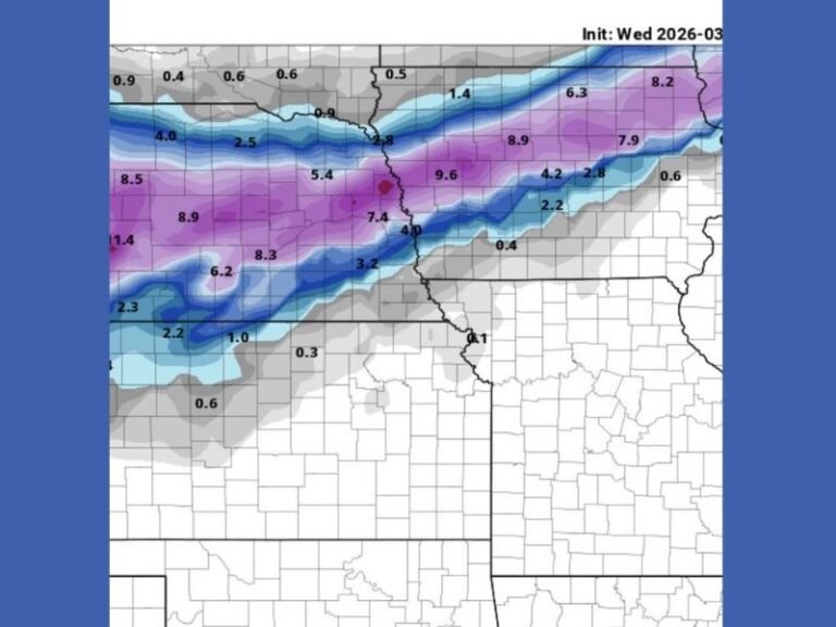
Heavy Snow Corridor Expected North of the Ice Zone
North of the ice threat, a broad corridor of heavy snow is increasingly likely, with 6 to 12 inches possible in portions of:
- Kansas
- Missouri
- Illinois
- Indiana
- Ohio
- Kentucky
- West Virginia
This region sits beneath the strongest lift and coldest profiles, favoring persistent snowfall rather than mixed precipitation. Even modest track shifts could expand or contract this snow axis, which remains under close observation.
Sleet Zone Could Become a Major Travel Hazard
Between the snow and freezing rain zones lies a sleet-dominated corridor, often the most frustrating part of winter storms. Sleet accumulates quickly, is extremely dense, and melts very slowly, turning roads into glacier-like surfaces.
Unlike freezing rain, sleet may not topple trees, but it can make road travel nearly impossible for hours or even days, especially when combined with sub-freezing temperatures.
Timing: Impacts Begin Saturday and Persist Into Sunday
Current timing suggests:
- Precipitation may begin as early as Saturday, intensifying through Saturday night
- Peak impacts likely Saturday night into Sunday
- Some areas may experience nearly 48 hours of wintry precipitation
Temperatures are expected to remain below freezing in many impacted regions, allowing ice and snow to accumulate efficiently with little melting.
Travel Disruptions and Power Outages Likely
Given the large geographic footprint of this storm, flight cancellations, highway shutdowns, and prolonged power outages are increasingly likely across the hardest-hit areas. Even locations that avoid heavy snow or ice may experience dangerous wind chills and refreezing after precipitation ends.
Residents are strongly urged to:
- Finalize travel plans early or postpone if possible
- Prepare for extended power outages
- Monitor forecasts closely as details sharpen
Forecast Confidence Increasing, But Final Details Still Evolving
While confidence in a high-impact event is growing, meteorologists stress that exact snow and ice lines can still shift over the next 24 hours. High-resolution model data and additional aircraft observations will help refine placement as the storm approaches.
Small adjustments in track could mean the difference between heavy snow and crippling ice for many communities. This storm should be taken seriously across all impacted regions.
What are you seeing where you live — snow, sleet, or ice concerns? Share your thoughts and stay weather-aware with ongoing updates from SaludaStandard-Sentinel.com.