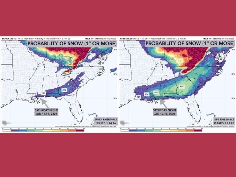
Southern Winter Storm Outlook Shows Split Models With Heavy Snow Risk for South Carolina, North Carolina, Georgia, Alabama, and Tennessee This Weekend
UNITED STATES — A developing winter storm expected to impact the southern United States later this weekend is drawing close attention from meteorologists, as key forecast models diverge on storm placement but agree on one outcome: enough snow to severely disrupt travel across parts of the Southeast, including South Carolina, North Carolina, Georgia, Alabama, and Tennessee.
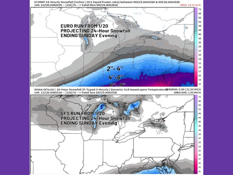
Forecast Models Split on Exact Track, Not on Impact
Latest data from the EURO (ECMWF) and GFS models show a clear split in how far north the heaviest snow band sets up. The EURO solution continues to nudge the snow axis northward, bringing heavier snowfall closer to parts of the southern Appalachians and interior Carolinas.
Meanwhile, the GFS scenario pushes the core impacts farther south, crippling sections of the Deep South while leaving the southern Ohio Valley and much of the Mid-Atlantic with minimal impacts. Despite this disagreement, both models indicate snowfall totals high enough to shut down road travel in affected areas.
Why Meteorologists Favor the EURO Scenario — For Now
Forecasters note that the EURO model has shown stronger consistency in similar setups three to seven days out, which gives it added credibility at this range. Its current solution suggests a broader and more impactful snow swath, particularly for elevated terrain and inland areas across the Southeast. However, meteorologists stress that this remains an evolving forecast, and confidence in precise placement will improve as the event draws closer.
Travel Disruptions Likely Regardless of Final Track
Even under the more southern GFS solution, snowfall amounts are projected to be sufficient to close highways, delay flights, and disrupt weekend travel plans.
Sunday currently appears to be the highest-risk day, especially for long-distance driving across southern interstates. Airports may attempt to operate between snow bands, but localized heavy snowfall could still ground flights with little notice.
Why This Storm Deserves Early Attention
Forecasters emphasize that computer models are guidance tools, not guarantees, and expectations should remain flexible. Small shifts in temperature profiles or storm speed could dramatically change where the heaviest snow ultimately falls. What is clear at this stage is that this system has the potential to create widespread winter travel hazards, even if final snowfall totals vary by location.
What Residents Should Be Thinking About Now
Residents across the Southeast are encouraged to re-evaluate weekend travel plans, monitor updated forecasts daily, and prepare for the possibility of snow-covered roads and delayed services. Emergency officials advise focusing on impact preparation rather than snowfall numbers, especially in regions where winter storms are rare and infrastructure is less equipped to handle snow.
If you live in South Carolina, North Carolina, Georgia, Alabama, or Tennessee, how are you preparing for the potential winter impacts this weekend? Share your thoughts and local conditions with the SaludaStandard-Sentinel.com community.