Kentucky Under Winter Weather Advisory for Overnight Slick Roads as Light Snow and Glazing Develop Ahead of Larger Storm System
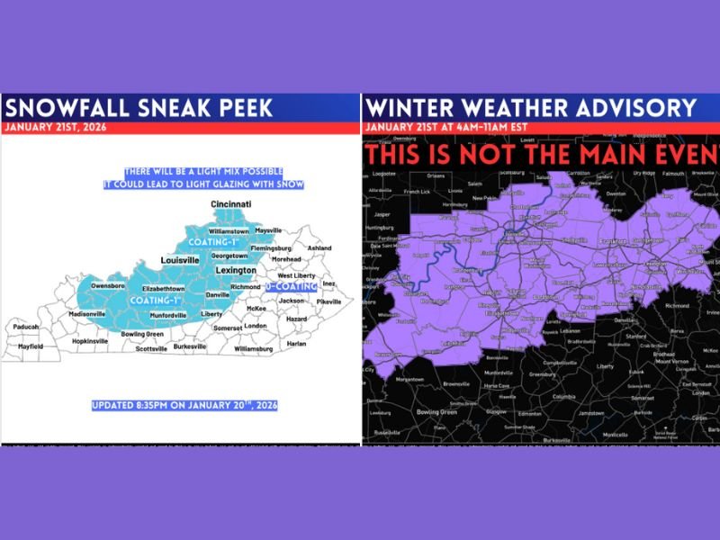
KENTUCKY — Much of Kentucky is under a Winter Weather Advisory overnight into mid-morning Wednesday, as a light but high-impact winter system moves through the region, bringing slick roads, light snow, and possible glazing, especially during the morning commute.
This Is a Nuisance System, Not the Main Event
Meteorologists stress that this is not the primary winter storm expected later in the week. However, despite being lighter in overall intensity, this system carries high nuisance potential due to cold ground temperatures that will allow precipitation to stick quickly.
Even small amounts of snow or freezing drizzle can create dangerous travel conditions when surfaces are already below freezing.
Light Snow and Glazing Likely Overnight Into Morning Commute
The advisory period runs from overnight through mid-morning Wednesday, with the greatest concern focused on early Wednesday travel. Forecast maps indicate light snow, with a mix possible, leading to thin ice glazing on untreated roads, bridges, and overpasses. When precipitation sticks rapidly, roads can transition from wet to slick in minutes, catching drivers off guard.
Areas Most Likely to See Slick Conditions
Central and western portions of Kentucky appear most vulnerable, including areas near Louisville, Lexington, Elizabethtown, Danville, and surrounding communities. Even locations expecting minimal accumulation could still experience hazardous driving conditions, particularly on side streets and secondary roads. Officials warn that low snowfall totals do not equal low impact in situations like this.
Why Cold Temperatures Increase Risk
With temperatures already well below normal, any snow or drizzle that falls will freeze on contact, increasing the likelihood of black ice. This makes the advisory especially important despite the system’s lighter appearance on radar.
Meteorologists emphasize that visibility may remain good, but traction could be poor — one of the most dangerous winter driving scenarios.
Travel Caution Strongly Advised Wednesday Morning
Drivers are urged to slow down, increase following distance, and allow extra time for the Wednesday morning commute. Pedestrians should also use caution on sidewalks, steps, and parking lots, which may become slick before sunrise. While impacts should ease later in the morning, officials caution that isolated slick spots may linger into late morning hours.
Bigger Winter System Still Ahead
Forecasters reiterate that this advisory-level event is only a precursor to a more significant winter system expected later in the week. This makes it especially important for residents to avoid complacency and stay alert as conditions evolve.
How are conditions where you live this morning? Are roads slick in your area? Share your observations and experiences with the SaludaStandard-Sentinel.com community.