Texas, Oklahoma, Arkansas, Tennessee, and the Deep South Face Crippling Ice Storm Risk as Half-Inch Ice Threshold Signals Widespread Infrastructure Failure
SOUTHERN UNITED STATES — Meteorologists are expressing high confidence that a dangerous winter storm scenario is unfolding across Texas, Oklahoma, Arkansas, Tennessee, and parts of the Deep South, with ice accumulation approaching or exceeding the critical one-half inch threshold, a level widely considered the tipping point between disruption and crippling infrastructure failure.
Why a Half Inch of Ice Changes Everything
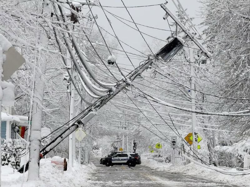
Forecasters stress that ice is far more destructive than snow due to its sheer weight and ability to cling to infrastructure. A 0.50-inch ice accumulation can add up to 500 pounds of extra weight to a single span of power lines, while placing roughly 30 times the normal load on tree branches.
Even in calm conditions, this amount of ice is enough to snap healthy limbs, pull down utility poles, and collapse power distribution networks, setting the stage for widespread outages.
Power Outages Become Widespread and Prolonged at This Threshold
Once ice accumulation reaches the half-inch mark, outages typically shift from isolated to region-wide and long-lasting.
Ice amounts between 0.10 and 0.25 inches often cause brief flickers or short-term outages. Between 0.25 and 0.50 inches, outages become more numerous and can last hours to a full day. At 0.50 inches and above, damage to the power grid is often severe, with electricity potentially out for days or even a week, especially if winds increase or soils are soft.
Utility crews often cannot begin repairs until conditions improve, further delaying restoration.
Travel Conditions May Become Virtually Impossible
Meteorologists warn that half an inch of solid ice glaze renders roads effectively impassable. Traction drops to zero, meaning even four-wheel-drive vehicles cannot steer or stop safely.
In addition to slick surfaces, downed trees and power lines frequently block roads, preventing emergency vehicles and utility crews from reaching affected neighborhoods. In past events, entire communities have been temporarily isolated due to blocked access.
SPIA Index Signals High-End Ice Storm Damage Potential
Experts use the Sperry–Piltz Ice Accumulation (SPIA) Index, a scale similar to the Richter scale for earthquakes, to estimate ice storm severity. A storm producing 0.50 inches of ice with even modest winds of 15 to 25 mph is typically rated Level 4 out of 5, a category associated with prolonged and widespread utility interruptions.
This places the current setup firmly in the high-impact, high-damage category, rather than a routine winter weather event.
Confidence Is High as Early Warnings Now Verify
Meteorologists note that this scenario was flagged more than a week in advance, with forecast confidence steadily increasing rather than decreasing. Early alerts were issued precisely because the pattern showed red flags from the outset, particularly the overlap of Arctic air and prolonged freezing rain potential.
Forecasters caution that while exact ice totals may still vary, the risk itself is no longer in question.
Residents Urged to Prepare for Extended Disruptions
Officials urge residents across affected states to prepare now, including securing food, water, medications, and backup heating options. Extra care should be taken to protect pets, livestock, and vulnerable neighbors, and to avoid travel once freezing rain begins.
Preparation is strongly advised as a practical safety step, not a cause for panic, as conditions could deteriorate rapidly once ice begins accumulating.
If your area has experienced damaging ice storms in the past, how are you preparing for this one? Share your experiences and preparedness tips with the SaludaStandard-Sentinel.com community.