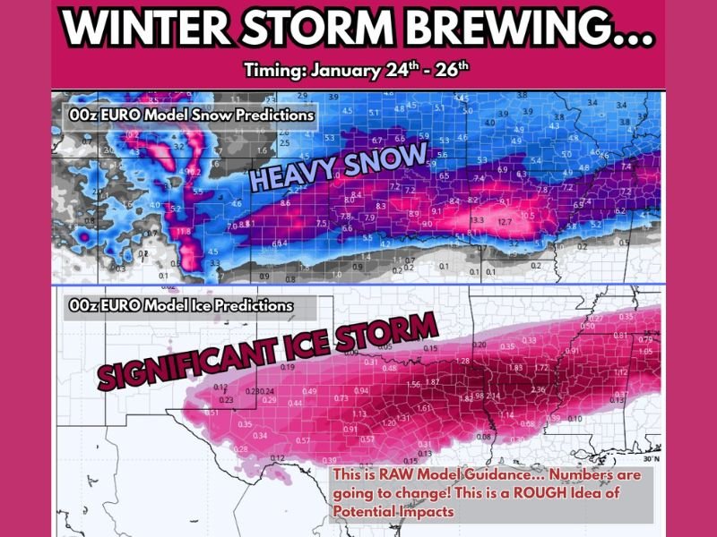
Strong Winter Storm Signal Emerges for Texas, Oklahoma, Arkansas, and the Deep South as Snow and Significant Ice Threaten January 24–26
SOUTHERN UNITED STATES — Confidence is growing among meteorologists that a potentially impactful winter storm could develop across Texas, Oklahoma, Arkansas, and parts of the Deep South between January 24 and January 26, as major forecast models continue trending stronger and more aligned.
Forecast Models Now Aligning on a Stronger Winter Storm
Recent model runs show the GFS model shifting closer to the European (EURO) solution, a key signal that forecasters often watch closely. With multiple models now in agreement, confidence is increasing that this system could bring widespread winter weather impacts rather than a marginal or narrowly focused event.
Meteorologists stress that while exact snowfall and ice amounts remain uncertain, the overall storm structure suggests a high-impact setup, especially for areas that rarely experience prolonged winter conditions.
Heavy Snow Potential Across the Southern Plains and Lower Midwest
Current guidance indicates a corridor of heavy snow may develop across parts of Texas, Oklahoma, Arkansas, and neighboring states, depending on the final storm track. In these areas, cold air already in place could support accumulating snowfall capable of disrupting travel and daily routines.
Forecasters caution that small shifts in the storm’s path could move the heaviest snow zone north or south, but the signal for meaningful snowfall is becoming increasingly difficult to ignore.
Significant Ice Storm Risk for the Deep South
Perhaps the most concerning aspect of this system is the growing indication of a significant ice storm across parts of the Deep South, where freezing rain may dominate. Ice accumulation poses a serious threat due to its ability to down trees, damage power lines, and cause long-lasting power outages.
Even moderate ice totals can lead to dangerous road conditions and widespread infrastructure issues, particularly in regions not designed for winter storms of this magnitude.
Timing Window: January 24 Through January 26
The most likely impact window currently spans Friday through Sunday, with winter weather potentially beginning late Friday and lingering into the weekend. This extended duration increases the risk of compounding impacts, especially if ice and snow overlap in some areas.
Meteorologists emphasize that this is still raw model guidance, meaning changes are expected. However, the overall risk footprint is becoming clearer, even as finer details remain unresolved.
Preparation Encouraged Ahead of Possible Impacts
Residents in potentially affected areas are encouraged to begin preparation now, focusing on non-perishable food, warm clothing and blankets, and ensuring pets and farm animals can remain protected from cold and ice. Trimming dead branches and securing outdoor items could also reduce storm-related damage.
Forecasters stress that preparation should be calm and practical, not driven by fear, as updated forecasts will refine expected impacts over the coming days.
As confidence continues to evolve, additional updates are expected as January 24 approaches.
If you live in Texas, Oklahoma, Arkansas, or the Deep South, how are you preparing for the possibility of winter weather later this month? Share your thoughts and experiences with the SaludaStandard-Sentinel.com community.