Arctic Air Surge and Southern Storm Track Could Bring a Snow-Ice Mix to the Southeast, Including the Carolinas and Georgia, Next Weekend
UNITED STATES — Meteorologists are closely watching a developing late-January winter setup that could impact large portions of the southern and eastern United States next weekend, as Arctic air pushes southward and a southern storm system tracks east along the Gulf Coast between January 24 and January 25.
While confidence in exact impacts remains limited, the overall pattern now supports the potential for winter weather across parts of the South and Southeast, including the Carolinas and Georgia.
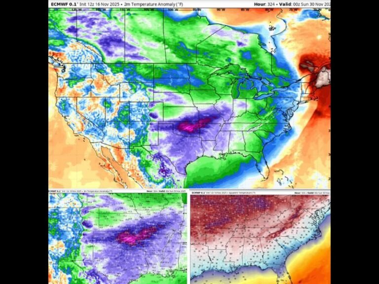
Arctic Air Expected to Surge Into the Eastern United States
Forecast guidance shows cold Arctic air advancing south and east, spreading across the Ohio Valley and into the Mid-Atlantic and Southeast. This cold air intrusion is expected to be well-established before the storm system arrives, which is a critical ingredient for wintry precipitation.
Meteorologists note that cold air already in place greatly increases the chance that precipitation falls as snow, sleet, or freezing rain, rather than plain rain.
Southern Storm Track Raises Snow and Ice Concerns
At the same time, a potential southern storm system is projected to move east from Texas across the Gulf Coast states, drawing moisture northward. As this moisture overruns the colder air, a band of wintry precipitation could develop from the southern Plains into the Southeast.
Current projections suggest a mix of snow and ice is possible across parts of Texas, Arkansas, Mississippi, Alabama, Georgia, and the Carolinas, though the exact placement of the transition zone remains uncertain.
Carolinas and Georgia Within the Potential Impact Zone
The latest model trends show North Carolina, South Carolina, and north Georgia sitting near the northern edge of the storm’s precipitation shield, where cold air and moisture overlap. This zone is often where snow or freezing rain becomes possible, especially during overnight or early-morning hours. Coastal areas may remain warmer, but inland locations could see brief wintry conditions if temperatures stay low enough.
Timing Focused on January 24–25 Weekend
The main window for potential impacts currently centers on Saturday into Sunday, January 24–25. At this range, meteorologists caution against focusing on snowfall totals or ice amounts, emphasizing that track shifts of even 50–100 miles could dramatically change outcomes. More precise details on locations, impacts, and precipitation types typically emerge within 48–72 hours of the event.
Winter Storm Not Guaranteed, but Pattern Bears Watching
Forecasters stress that a winter storm is possible but not a certainty, while the arrival of colder Arctic air is much more likely. Even if wintry precipitation is limited, colder-than-normal temperatures are expected across much of the eastern U.S.
Residents across the South and Southeast are encouraged to stay informed, especially as forecast confidence improves later this week. As this late-January weather pattern continues to evolve, readers are invited to share conditions from their area and follow continued updates at SaludaStandard-Sentinel.com.