High-Resolution Models Show Strong Southern Snow Signal for Sunday as Low-Pressure Track Becomes Critical Across the Southeast
SOUTH CAROLINA — Forecasters are now tracking stronger southern snow signals for Sunday as high-resolution models come into range and begin lining up with both the GFS and European guidance. This shift marks an important inflection point, bringing the forecast into a window where small-scale details start to matter and confidence begins to sharpen.
High-Res Guidance Confirms Snow but Shows Slightly Different Timing
The latest high-resolution data confirms snow is likely somewhere in the region, though the timing differs somewhat from earlier projections. According to the update, the newer guidance suggests:
- A Sunday lunchtime start,
- With snow continuing into Sunday afternoon and evening.
This timing refinement is significant because it aligns the high-resolution models with broader long-range trends, increasing confidence that the system will produce winter weather somewhere across the Southeast.
Model Differences Highlight the Key Question: Where Will the Snow Set Up?
Despite growing agreement that snow will occur, placement remains the biggest uncertainty.
- The European model continues to favor a track south of the Upstate, which would deliver more of a glancing blow to coastal Florida, Georgia and the Carolinas.
- The GFS, along with newly updated high-resolution models, shows a broader swath of snow, driven by a stronger low-pressure system farther south.
These competing scenarios illustrate how small deviations in storm track could shift who receives meaningful snowfall and who sees only lighter or passing impacts.
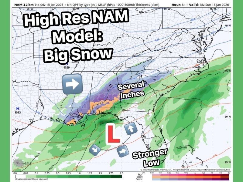
High-Res NAM Highlights Potential for “Big Snow”
The NAM graphic included in the update depicts:
- A stronger southern low,
- A defined precipitation shield,
- And an area marked “Several Inches” extending across parts of the Southeast.
This model run amplifies the possibility of a more impactful snowfall if the low-pressure center deepens and maintains a favorable southern track.
While not a guarantee, the pattern shown is consistent with setups that have produced notable southern snow events in past years.
Forecast Now Hinges on Low-Pressure Track and Placement
From here, forecasters emphasize that everything depends on the track and strength of the low-pressure system.
Small adjustments over the next 24–48 hours could dramatically change snowfall placement and overall totals.
Early indications suggest a near-ideal setup for a potentially meaningful southern snowfall, but meteorologists stress the need for consistency across model runs before raising confidence levels further.
More Updates Expected as Models Continue Converging
With high-resolution data now in range and each new run offering clearer insight, forecasters encourage residents across the region to stay tuned for rapidly evolving updates.
Readers can follow continuing developments at SaludaStandard-Sentinel.com and share local conditions as Sunday approaches.