Long-Range EURO Model Shows Strong Signal for Major Polar Vortex Disruption That Could Bring Severe Eastern U.S. Cold Late January
SOUTH CAROLINA — Long-range weather data is showing what forecasters describe as “extremely eye-popping signals” for the final week of January, with the European model consistently projecting a pattern capable of delivering extreme cold waves into the eastern United States. The setup resembles several historic episodes of severe to extreme cold, including winters marked by major arctic blasts and large winter storms.
EURO Model Resembles Past Extreme-Cold Years
Based on the detailed comparison, the emerging pattern shares similarities with notable cold outbreaks from:
- 1977
- 1985
- 2013
- 2021
- 2022
The update highlights that some of the most extreme U.S. cold events in the past century appeared in years such as 1985, 2022, 1977 and January 2021.
Further analysis notes additional years that strongly resemble the end-of-January 2026 forecast because they featured a strong easterly QBO (quasi-biennial oscillation). Those years include:
- 1966
- 1969
- 1985
- 2010
- 2013
Each of these cases involved significant arctic air outbreaks or major winter storms across the U.S.
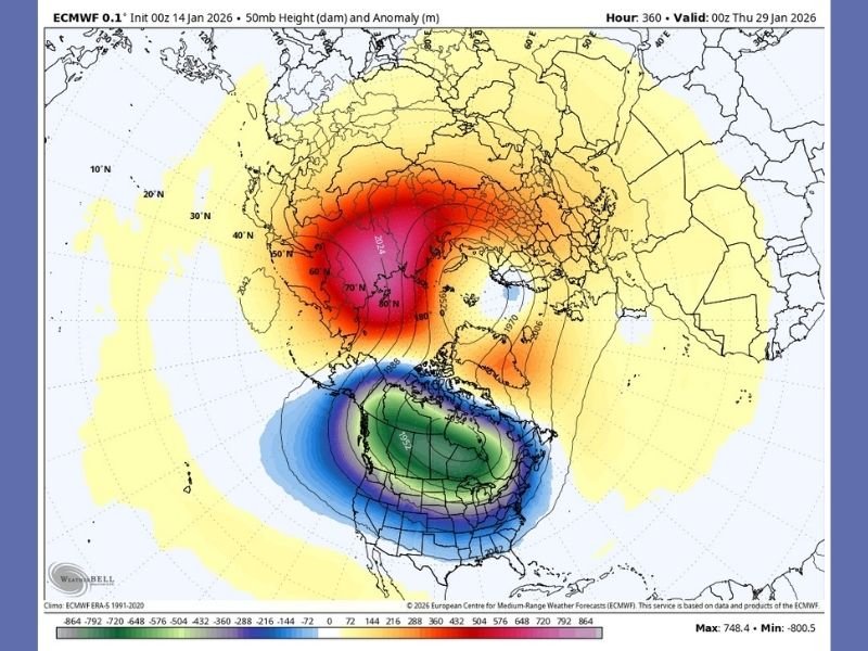
EURO Map Shows Clear High-Latitude Disruption Pattern
The ECMWF map included in the update shows a classic high-latitude configuration associated with a major polar vortex disruption, with large negative height anomalies centered over North America.
The pattern displayed suggests the potential for Arctic air to sink toward the continental United States as the vortex weakens.
Forecasters describe the model output as loud and clear, signaling the possibility of one prolonged or several short episodes of very extreme cold spreading across the eastern U.S. near the end of January.
Forecaster Says Odds Are “Moderate to High” for Major Cold Outbreak
While exact temperature numbers cannot be forecast at this range, the discussion notes that the signal itself is unusually strong within the most reliable long-range modeling.
The forecaster states that:
- A major polar vortex disruption is possible.
- The eastern U.S. may see big, possibly very big cold in the final seven days of January.
- Model confidence is increasing, not decreasing.
Although traditional forecasting tools cannot yet identify exact impacts, the long-range indicators are far more consistent than typical high-range projections.
Why Long-Range Forecasting Matters for Big Weather Patterns
In addressing skepticism, the update points out that long-range forecasting is often more accurate at predicting large-scale patterns than short-term rainfall totals. Industries such as energy, commodities and hedge funds routinely rely on long-range atmospheric modeling to prepare weeks to months in advance.
Because of the strength and persistence of these signals, forecasters stress that the final week of January should be watched closely for a potential major cold event.
The Saluda Standard-Sentinel will continue monitoring new model runs and provide updated coverage as clarity increases. Readers are encouraged to share how they are preparing for potential late-January cold at SaludaStandard-Sentinel.com.