Northern Florida Could See Snowflakes Sunday as European and American Models Show Wintry Potential, but Confidence Remains Low
FLORIDA — New model guidance suggests the possibility of snow reaching northern Florida on Sunday, with both the American (GFS) and European (EURO) models showing a band of wintry precipitation dipping into the region. While the idea has captured attention, forecasters caution that confidence remains low due to inconsistent model behavior and temperatures that may not support meaningful accumulation.
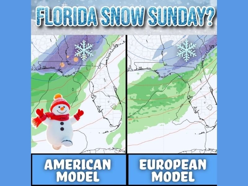
Both Major Models Show Snow Into Northern Florida
The comparison graphics highlight two model scenarios:
- The American model shows a zone of frozen precipitation extending southward into northern Florida, with surrounding areas of moisture spreading across Alabama and Georgia.
- The European model similarly displays snow over northern Florida, aligning with the broader regional setup but remaining dependent on exact temperature timing.
These overlapping signals indicate that flakes are possible, but not guaranteed.
Surface Temperatures Likely Too Warm for Accumulation
Forecasters emphasize that although it may be cold enough aloft for snow to fall, the ground across northern Florida is expected to remain above freezing. This means any flakes that do reach the surface would be very limited and unlikely to accumulate.
The update further states that “very limited to no accumulation is likely in Florida,” even if snow does occur. The situation may be different for neighboring states such as Georgia, Alabama and the Carolinas, where colder surface temperatures could allow for more noticeable impact.
Models Have Been Inconsistent, Lowering Forecast Confidence
The early message urges residents not to overreact, noting that the models have been “very inconsistent” in recent days.
Because of this variability:
- Forecast confidence remains low.
- Timing and moisture could shift significantly.
- Any snowfall potential should be viewed as worth watching, but far from certain.
This aligns with the cautionary note that it is still “too early to know” whether snow will indeed occur.
A Watchful but Cautious Outlook for the Gulf Region
Despite the excitement surrounding the possibility of Florida snow — a rare event in itself — meteorologists stress a measured outlook. Cold air and moisture must align perfectly for even minor snow to develop, and that alignment is often difficult along the Gulf Coast.
Updates will continue as forecasters monitor how much moisture arrives and just how cold temperatures get heading into Sunday. Readers can share whether their area is preparing for possible flurries at SaludaStandard-Sentinel.com.