Weekend Snow Possible Across Mississippi, Alabama, Georgia, South Carolina, North Carolina, Tennessee and Northern Florida
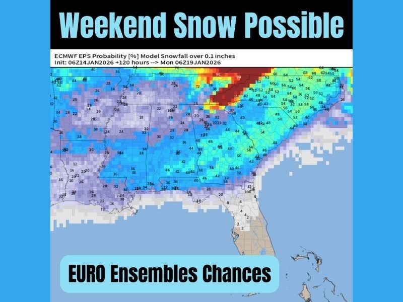
SOUTH CAROLINA — New EURO ensemble data is signaling increasing snowfall probabilities across several Southeastern states this weekend, highlighting measurable chances from Mississippi to the Carolinas and extending unusually far south into northern Florida. The model output reflects the likelihood of 0.1 inches or more of snowfall between Saturday and early Monday, showing a broad cold-weather pattern forming across the region.
EURO Ensemble Map Highlights Measurable Snow Potential
The forecast map displays widespread probability shading across multiple states, confirming that the weekend system carries regionwide interest. The model highlights measurable snow potential in:
- Mississippi and Alabama, where consistent light-to-moderate probability values appear across large areas.
- Georgia, showing clear shading extending from western into central and northern regions.
- South Carolina and North Carolina, where noticeable probability zones stretch across interior portions of each state.
- Tennessee, which features one of the strongest clusters of higher snowfall probabilities on the entire map.
- Northern Florida, where the map shows low-end but visible snowfall percentages, signaling a rare cold-weather setup for the region.
These probabilities represent the model’s estimate of receiving 0.1 inches or more of snowfall within the forecast window.
Snow Interest Rises as Model Trends Hold Steady
Across the Southeast, winter weather discussions have increased as the EURO ensemble continues to show steady signals for weekend snow. While the map does not provide snowfall totals, the probability shading alone indicates that several states may experience flurries or light measurable accumulation if the system aligns as projected.
Higher probability concentrations across Tennessee and parts of the western Carolinas suggest these regions could be among the more likely areas to see noticeable flakes. Meanwhile, broader lighter shades across Mississippi, Alabama and Georgia reflect a more widespread but less intense signal.
Northern Florida Included in Rare Snow Probability Zone
One of the most noteworthy details from the map is the appearance of snow probability shading in northern Florida. Although the values are low, the presence of any measurable chance is unusual for the state, indicating how far south this cold pattern may reach. The shading confirms that the system is broad enough to influence even areas not typically included in winter weather discussions.
As the weekend nears, residents across all highlighted states may want to follow updated local forecasts for clearer timing and potential impact. The Saluda Standard-Sentinel will continue monitoring model trends and update readers as new information develops.
Readers can share their weekend expectations and any early signs of winter weather in their area at SaludaStandard-Sentinel.com.