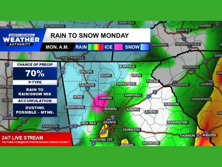
Western North Carolina and East Tennessee Mountains Targeted for Highest Snow Totals as Upslope Pattern Limits Snow Elsewhere
NORTH CAROLINA & TENNESSEE — A developing winter weather setup late Wednesday night into Thursday is expected to deliver the most significant snowfall to the mountains of western North Carolina and eastern Tennessee, while areas outside higher elevations face sharply reduced and inconsistent impacts.
Mountains Favored for Meaningful Snow Accumulation
Forecast data shows a classic northwest-flow upslope snow event, a pattern that strongly favors the Smoky Mountains and higher elevations of western North Carolina and eastern Tennessee. As cold air moves across the region, it is forced upward along the terrain, enhancing snowfall in mountain zones.
Snow totals of 4 to 7 inches are possible in the highest elevations, particularly in the Smokies and along favored ridgelines. Surrounding mountain communities may see 2 to 4 inches, with snowfall intensity increasing with elevation.
Sharp Drop-Off in Snowfall Outside the Mountains
Once away from the mountains, snowfall potential decreases rapidly. Areas immediately east of the Blue Ridge are expected to fall into a snow-shadow zone, where downslope winds limit accumulation.
Most lower elevations outside the mountains are forecast to see 1 to 2 inches at most, with many locations receiving little or no measurable snow. Accumulation in these areas will depend on brief, localized bursts rather than sustained snowfall.
Quick Snow Showers Possible Early Thursday Morning
Forecast models suggest a narrow window for flurries or snow showers early Thursday morning, driven primarily by upper-level energy rather than a classic storm system. This means snowfall coverage will be uneven, with some communities seeing flakes while nearby areas remain dry.
Because this is not a surface-driven storm, no guarantees exist outside the mountains, and snow totals will vary significantly over short distances.
Travel Concerns Despite Limited Accumulation
Even where snowfall remains light, slick spots cannot be ruled out, especially with frozen ground already in place. A brief heavier snow burst could create isolated travel issues during the Thursday morning commute, particularly on bridges, overpasses, and untreated roads.
However, widespread travel disruptions are unlikely outside mountain areas.
Bottom Line: Elevation Will Decide Impacts
This event will be highly terrain-dependent, with meaningful, high-impact snow confined mainly to mountain regions. Those seeking winter weather will find it in the higher elevations, while communities outside the mountains should expect limited effects.
Residents are encouraged to adjust expectations based on elevation and location, as this setup does not support widespread snowfall. Stay with SaludaStandard-Sentinel.com for continued updates as timing and snowfall placement become more refined.